Rossithidium pusillum
-
Category
-
Length Range10–16 µm
-
Width Range3.1-4.1 µm
-
Striae in 10 µm20-24
-
SynonymsAchnanthes pusilla Grunow in Cleve and Grunow 1880
Achnanthidium pusillum (Grunow) Czar. 1995
-
ContributorMarina Potapova - May 2009
-
ReviewerSarah Spaulding - May 2010
Identification
Description
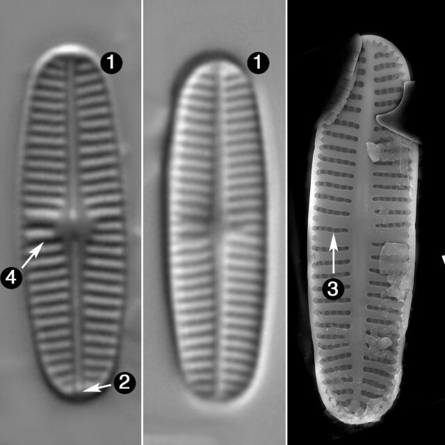
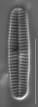
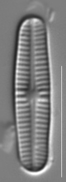
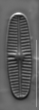
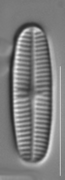
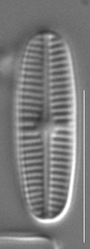
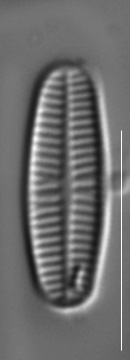
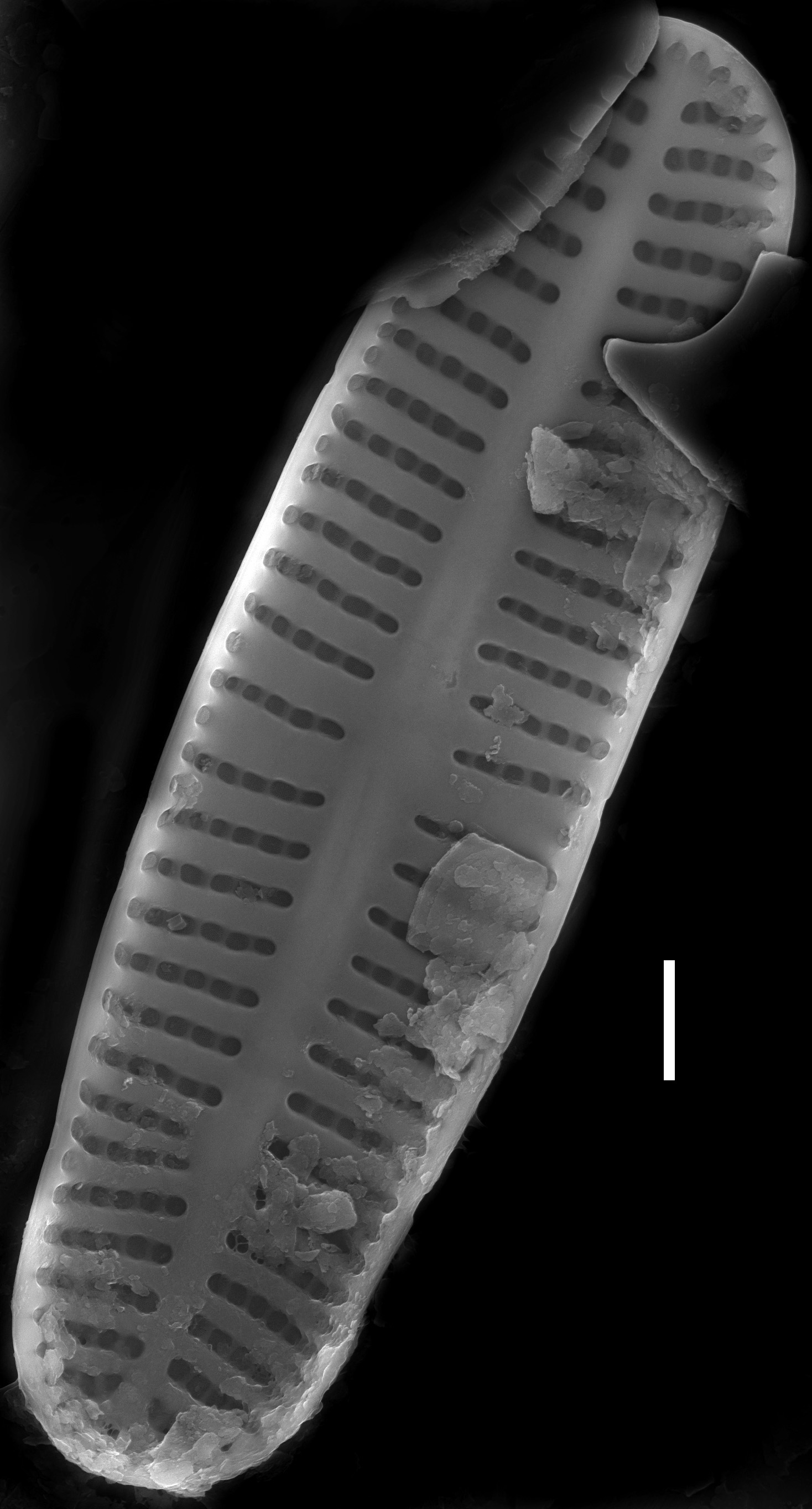
Valves linear or linear-elliptical with rounded ends, 3.1-4.1 µm wide, 10-16 µm long. Raphe valve with narrow axial area and with small round or irregular central area. Terminal raphe fissures absent. Raphe straight, filiform. Central raphe endings curved to opposite sides internally. Rapheless valve with narrow linear axial area without a central area or with a very small asymmetrical central area. Striae uniseriate, slightly radiate, one or two striae in the middle portion of the raphe valve are thicker than the rest, 20-24 in 10 µm. External openings of areolae are isodiametric or slightly elongated transapically. Each stria in the middle part of the valve contains 4-5 areolae. The valve mantle bears one row of areolae.
Autecology
As other monoraphid diatoms, Rossithidium pusillum is only slightly motile. Coldwater, oligotraphentic species.
-
Size Range, µm3
-
Motility
-
Attachment
-
Habitat
-
BCG
-
Waterbody
-
Distribution
- Learn more about this
Original Description
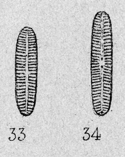
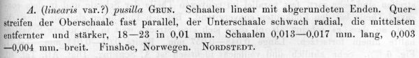
Schaalen linear mit abgerundeten Enden. Querstreifen der Overschaale fast parallel, der Unterschaale schwach radial, die mittelsten entfernter und starker, 18-23 in 0.01 mm. Schaalen 0,013-0,017 mm. lang, 0.003-0,004 mm breit. Finshoe, Norwegen. Nordstedt.
-
BasionymAchnanthes pusilla
-
AuthorGrunow 1880
-
Length Range13-17 µm
-
Width3–4 µm
-
Striae in 10µm18-23 in 10 µm
Original Images
Citations & Links
Citations
Cite This Page
Potapova, M. (2009). Rossithidium pusillum. In Diatoms of North America. Retrieved April 25, 2024, from https://diatoms.org/species/rossithidium_pusillum
Responses
The 15 response plots show an environmental variable (x axis) against the relative abundance (y axis) of Rossithidium pusillum from all the stream reaches where it was present. Note that the relative abundance scale is the same on each plot. Explanation of each environmental variable and units are as follows:
ELEVATION = stream reach elevation (meters)
STRAHLER = distribution plot of the Strahler Stream Order
SLOPE = stream reach gradient (degrees)
W1_HALL = an index that is a measure of streamside (riparian) human activity that ranges from 0 - 10, with a value of 0 indicating of minimal disturbance to a value of 10 indicating severe disturbance.
PHSTVL = pH measured in a sealed syringe sample (pH units)
log_COND = log concentration of specific conductivity (µS/cm)
log_PTL = log concentration of total phosphorus (µg/L)
log_NO3 = log concentration of nitrate (µeq/L)
log_DOC = log concentration of dissolved organic carbon (mg/L)
log_SIO2 = log concentration of silicon (mg/L)
log_NA = log concentration of sodium (µeq/L)
log_HCO3 = log concentration of the bicarbonate ion (µeq/L)
EMBED = percent of the stream substrate that is embedded by sand and fine sediment
log_TURBIDITY = log of turbidity, a measure of cloudiness of water, in nephelometric turbidity units (NTU).
DISTOT = an index of total human disturbance in the watershed that ranges from 1 - 100, with a value of 0 indicating of minimal disturbance to a value of 100 indicating severe disturbance.
Rossithidium pusillum
- Valve linear to linear-elliptical
- Raphe straight, without distinct terminal raphe fissures
- Striae unseriate, slightly radiate throughout both valves
- One or two striae in the center of the raphe valve more broad than the other striae
Valves are linear to linear-elliptical or linear-lanceolate with rounded ends. The terminal raphe fissures are not distinct. The striae are uniseriate, with 4-5 areolae per stria, and slightly radiate throughout both valves.