Navicula piercei
-
Category
-
Length Range64-76 µm
-
Width Range6.8-8.0 µm
-
Striae in 10 µm11-13
-
ContributorLoren Bahls - Mar 2012
-
ReviewerMark Edlund - May 2012
Identification
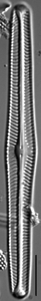
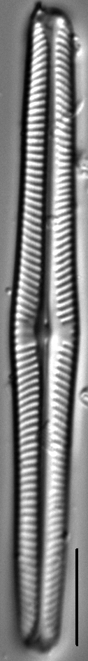
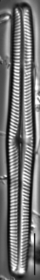
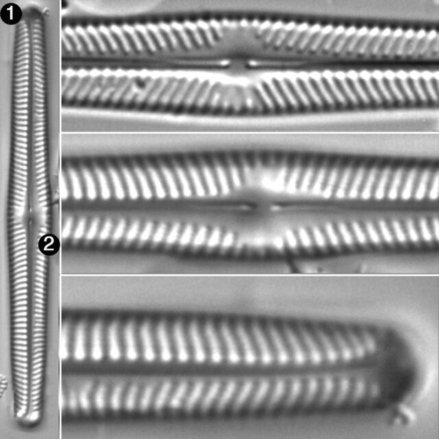
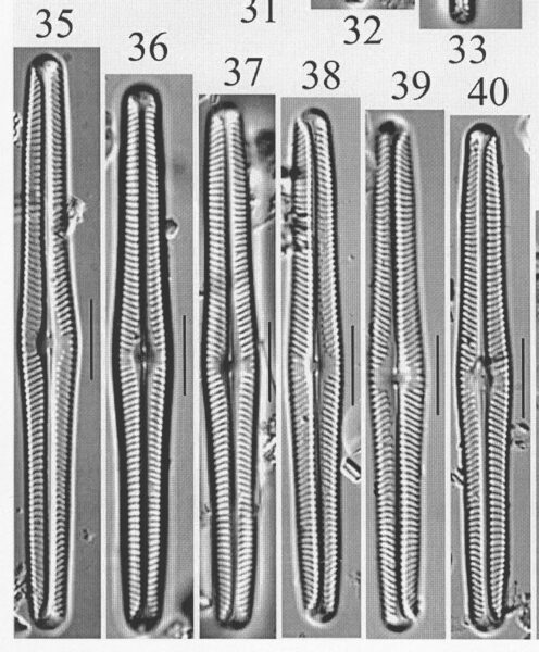
Description
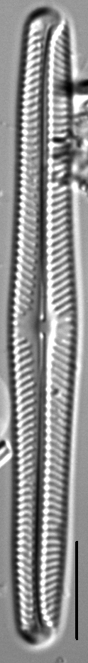
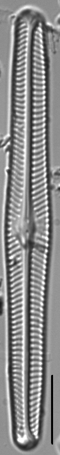
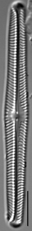
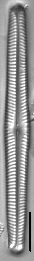
Valves are linear and subtly triundulate with a distinctly tumid middle and broadly rounded, somewhat wedge-shaped apices. Raphe branches are weakly lateral. Proximal raphe ends are straight or deflected slightly to the secondary side. Distal raphe fissures are hooked to the secondary side. The axial area is very narrow and linear. The central area is elliptical and asymmetric, bordered by 2-5 irregularly shortened and often faint striae. Striae are radiate, becoming convergent at the ends. Areolae in the striae number about 30 in 10 μm and are usually visible in LM.
Autecology
Navicula piercei is known only from Copper Lake in Shoshone County, northern Idaho. Here, on the date the holotype sample was collected, pH was 7.5 and specific conductance was 40 μS/cm.
-
Size Range, µm3
-
Motility
-
Attachment
-
Habitat
-
Colony
-
Waterbody
- Learn more about this
Original Description
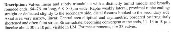
Valves linear and subtly triundulate with a distinctly tumid middle and broadly rounded ends, 64 –76 μm long, 6.8 – 8.0 μm wide. Raphe weakly lateral, proximal raphe endings straight or deflected slightly to the secondary side, distal fissures hooked to the secondary side. Axial area very narrow, linear. Central area elliptical and asymmetric, bordered by irregularly shortened and often faint striae. Striae radiate, becoming convergent at the ends, 11–13 in 10 μm, lineolae about 30 in 10 μm, visible in LM. For measurements, n = 23 valves.
-
AuthorBahls 2012
-
Length Range64-76 µm
-
Width6.8-8.0 µm
-
Striae in 10µm11-13
Original Images
Cite This Page
Bahls, L. (2012). Navicula piercei. In Diatoms of North America. Retrieved April 19, 2024, from https://diatoms.org/species/navicula_piercei
Responses
The 15 response plots show an environmental variable (x axis) against the relative abundance (y axis) of Navicula piercei from all the stream reaches where it was present. Note that the relative abundance scale is the same on each plot. Explanation of each environmental variable and units are as follows:
ELEVATION = stream reach elevation (meters)
STRAHLER = distribution plot of the Strahler Stream Order
SLOPE = stream reach gradient (degrees)
W1_HALL = an index that is a measure of streamside (riparian) human activity that ranges from 0 - 10, with a value of 0 indicating of minimal disturbance to a value of 10 indicating severe disturbance.
PHSTVL = pH measured in a sealed syringe sample (pH units)
log_COND = log concentration of specific conductivity (µS/cm)
log_PTL = log concentration of total phosphorus (µg/L)
log_NO3 = log concentration of nitrate (µeq/L)
log_DOC = log concentration of dissolved organic carbon (mg/L)
log_SIO2 = log concentration of silicon (mg/L)
log_NA = log concentration of sodium (µeq/L)
log_HCO3 = log concentration of the bicarbonate ion (µeq/L)
EMBED = percent of the stream substrate that is embedded by sand and fine sediment
log_TURBIDITY = log of turbidity, a measure of cloudiness of water, in nephelometric turbidity units (NTU).
DISTOT = an index of total human disturbance in the watershed that ranges from 1 - 100, with a value of 0 indicating of minimal disturbance to a value of 100 indicating severe disturbance.
Navicula piercei
- Valves linear, elongate
- Valve margin with tumid center
Navicula piercei has long linear valves with a tumid center.