Eunotia bactriana

-
Category
-
Length Range31.4-38.4 µm
-
Width Range5.0-6.4 µm
-
Striae in 10 µm14-16 at mid-valve; up to 18 at valve ends
-
Contributor
-
ReviewerSarah Spaulding - Jun 2016
Identification
Description
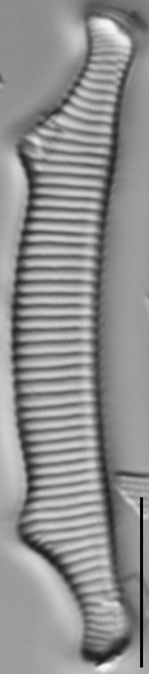
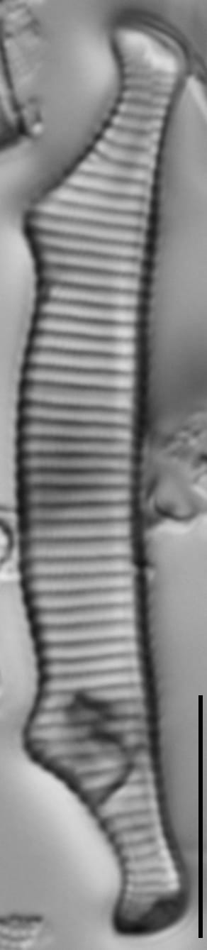
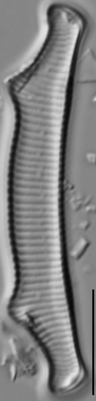
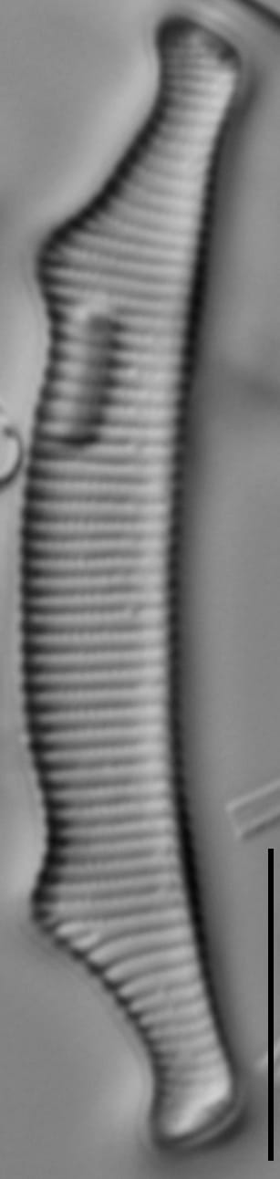
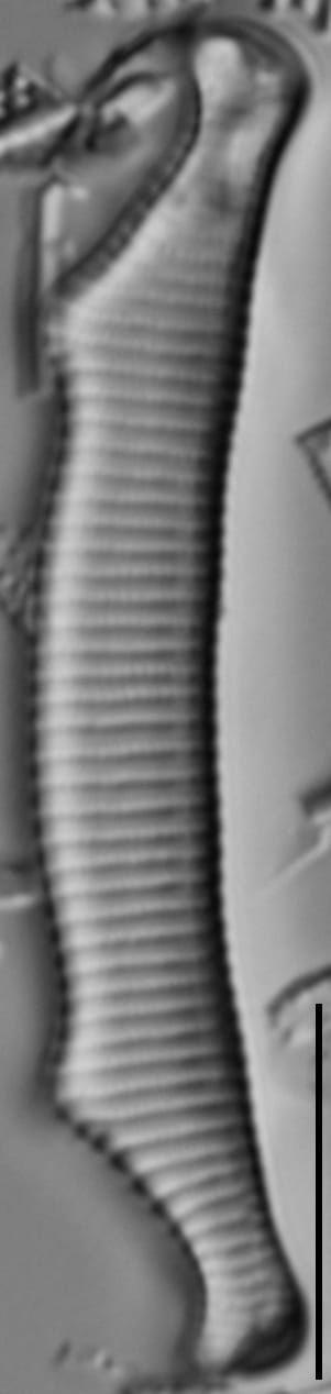
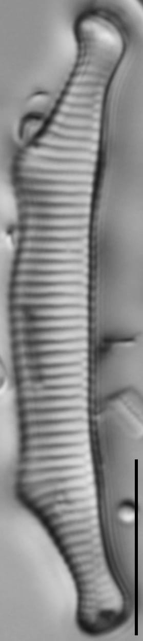
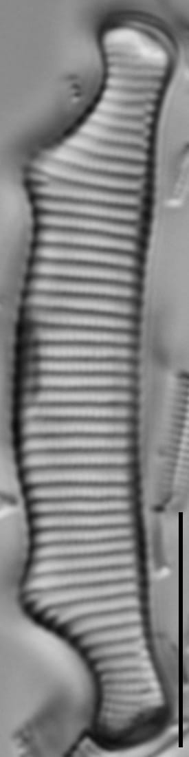
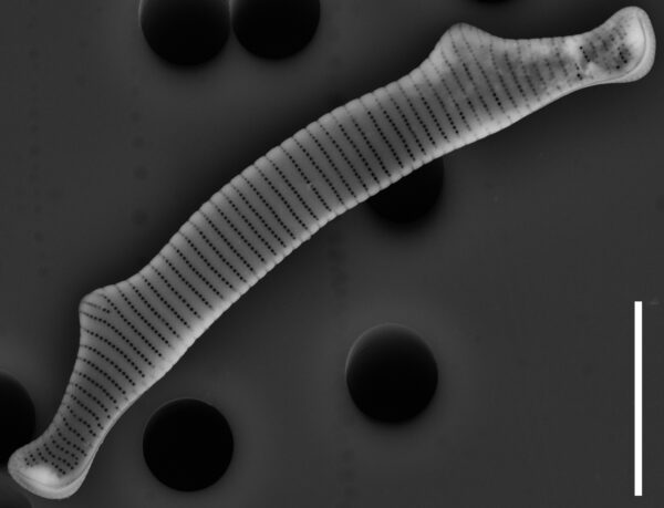
Valve outline is complex. The dorsal margin is convex and contains two prominent, pointed, widely-set undulations. Between these undulations, the dorsal margin may become less uniformly convex in smaller valves. The ventral margin is concave but becomes more linear in smaller specimens. The ventral margin also has subtle undulations where the valve is widest. Apices are capitate and dorsally recurved. Terminal raphe ends are visible near the apices. Striae are evenly spaced through most of the valve, becoming slightly denser at the apices. Areolae are dense and only barely visible with ideal illumination in LM.
Autecology
This taxon is rare, occurring across a wide geographical range but absent from large parts of Europe and North America, primarily limited to alpine, boreal, subarctic and arctic habitats (Lange-Bertalot et al. 2011). It has been reported with light micrographs from lakes in the Northeastern US (Camburn and Charles 2000), and Oregon (Bahls 2021).
In the Great Lakes National Parks (Edlund et al. 2009, 2011, 2012, 2013), this taxon is rare (0.1-1% abundance) at Apostle Islands (Outer Lake). It is reported to occur in mountain lakes with cool circumneutral to moderately acidic water of very low conductivity (Lange-Bertalot et al. 2011, Bahls 2021). Reported to occur in oligotrophic to dystrophic systems (Lange-Bertalot et al. 2011). The population imaged above was collected at Kings Lake Bog, a small, well protected, oligotrophic, lowland sphagnum bog in the Puget Trough (Lebednik and del Moral 1976).
Several research groups consider this taxon an indicator organism and published regional environmental optima and tolerances including:
Camburn and Charles (2000): pH - 5.13 +/- 0.45, Acid Neutralizing Capacity - (-2) +/- 12 µeq/L, Total Aluminum - 257 +/- 185 µg/L, Dissolved Organic Carbon - 149 +/- 100 µmol/L, Total Phosphorus - 3.58 +/- 2.77 µg/L for populations from the Northeastern US.
-
Size Range, µm3
-
Motility
-
Attachment
-
Habitat
-
Waterbody
-
Distribution
- Learn more about this
Original Description
-
AuthorEhrenb. 1854
Original Images

Citations & Links
Citations
-
Publication Link: 10.1007/s10933-008-9296-1
-
Publication Link: 10.11646/phytotaxa.86.1.1
Links
-
Index Nominum Algarum
-
North American Diatom Ecological DatabaseNADED ID: 33003
Updates
Feb 05, 2026 - Addition of Autecology and SEM
From 2016 until 2026, the autecological information on this taxon page was limited. As of this update, a SEM and information on ecology, biogeography, and environmental optima have been added. - Lane Allen and Mark Edlund
Cite This Page
Bishop, I., Edlund, M., Allen, L. (2016). Eunotia bactriana. In Diatoms of North America. Retrieved July 22, 2026, from https://diatoms.org/species/51342/eunotia_bactriana
Responses
The 15 response plots show an environmental variable (x axis) against the relative abundance (y axis) of Eunotia bactriana from all the stream reaches where it was present. Note that the relative abundance scale is the same on each plot. Explanation of each environmental variable and units are as follows:
ELEVATION = stream reach elevation (meters)
STRAHLER = distribution plot of the Strahler Stream Order
SLOPE = stream reach gradient (degrees)
W1_HALL = an index that is a measure of streamside (riparian) human activity that ranges from 0 - 10, with a value of 0 indicating of minimal disturbance to a value of 10 indicating severe disturbance.
PHSTVL = pH measured in a sealed syringe sample (pH units)
log_COND = log concentration of specific conductivity (µS/cm)
log_PTL = log concentration of total phosphorus (µg/L)
log_NO3 = log concentration of nitrate (µeq/L)
log_DOC = log concentration of dissolved organic carbon (mg/L)
log_SIO2 = log concentration of silicon (mg/L)
log_NA = log concentration of sodium (µeq/L)
log_HCO3 = log concentration of the bicarbonate ion (µeq/L)
EMBED = percent of the stream substrate that is embedded by sand and fine sediment
log_TURBIDITY = log of turbidity, a measure of cloudiness of water, in nephelometric turbidity units (NTU).
DISTOT = an index of total human disturbance in the watershed that ranges from 1 - 100, with a value of 0 indicating of minimal disturbance to a value of 100 indicating severe disturbance.
Eunotia bactriana
- Dorsal margin with two pointed undulations
- Ventral margin concave
- Apices dorsally recurved, capitate
- Striae evenly spaced
The dorsal margin is convex and contains two prominent, pointed, widely-set undulations. The ventral margin is concave, becoming more linear in smaller specimens. Apices are capitate and dorsally recurved. Striae are evenly spaced through most of the valve, becoming slightly more dense at the apices.