Aulacoseira alpigena

-
Category
-
Diameter4-15 µm
-
Width Range4-7 µm
-
Striae in 10 µm15-22
-
Reported AsAulacoseira distans var. septentrionalis (Camburn & Charles 2000)
-
ContributorMarina Potapova - May 2009
-
ReviewerSarah Spaulding - May 2010
Identification


Description
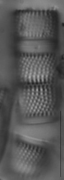
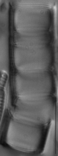
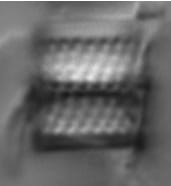
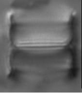
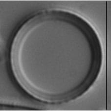
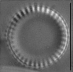
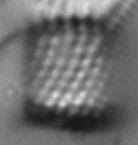
Frustules are cylindrical and 4-15 µm in diameter, with a mantle height of 4-7 µm. The ratio of the mantle height to valve diameter is less than 1. The mantle has convex sides and the valve face is flat. Rows of pervalvar areolae are curved to the right (dextrorse) and number 15-22 in 10 µm. The valve face is unornamented except for one row of marginal areolae. Spines are located at the end of each pervalvar costa. Spines are thin and have an 'anchor' shape at the end. The ringleiste is small.
Some valves of A. alpigena have almost straight rows of mantle areolae that also may be almost parallel to the pervalvar axis. Such specimens have been often misidentified as A. distans (Ehrenberg) Simonsen. Crawford and Likhoshway (1999) examined the type material of A. distans and showed that it is characterized by numerous rimportulae that internally form short tubes, situated close to a very deep ringleiste. These rimportulae are easily observed in LM in valve views. A. alpigena does not have such prominent and numerous rimoportulae and differs from A. distans also by having higher density of mantle areolae, shallow ringleiste, and plain valve face.
Autecology
Oligotraphentic species
-
Size Range, µm3
-
Motility
-
Attachment
-
Habitat
-
BCG
-
Waterbody
-
Distribution
- Learn more about this
Original Description
-
BasionymMelosira distans var. alpigena
-
AuthorGrunow in Van Heurck 1882
Original Images


Citations & Links
Links
-
Index Nominum Algarum
-
GenBank
-
North American Diatom Ecological DatabaseNADED ID: 10028
Cite This Page
Potapova, M. (2009). Aulacoseira alpigena. In Diatoms of North America. Retrieved June 07, 2026, from https://diatoms.org/species/44420/aulacoseira_alpigena
Responses
The 15 response plots show an environmental variable (x axis) against the relative abundance (y axis) of Aulacoseira alpigena from all the stream reaches where it was present. Note that the relative abundance scale is the same on each plot. Explanation of each environmental variable and units are as follows:
ELEVATION = stream reach elevation (meters)
STRAHLER = distribution plot of the Strahler Stream Order
SLOPE = stream reach gradient (degrees)
W1_HALL = an index that is a measure of streamside (riparian) human activity that ranges from 0 - 10, with a value of 0 indicating of minimal disturbance to a value of 10 indicating severe disturbance.
PHSTVL = pH measured in a sealed syringe sample (pH units)
log_COND = log concentration of specific conductivity (µS/cm)
log_PTL = log concentration of total phosphorus (µg/L)
log_NO3 = log concentration of nitrate (µeq/L)
log_DOC = log concentration of dissolved organic carbon (mg/L)
log_SIO2 = log concentration of silicon (mg/L)
log_NA = log concentration of sodium (µeq/L)
log_HCO3 = log concentration of the bicarbonate ion (µeq/L)
EMBED = percent of the stream substrate that is embedded by sand and fine sediment
log_TURBIDITY = log of turbidity, a measure of cloudiness of water, in nephelometric turbidity units (NTU).
DISTOT = an index of total human disturbance in the watershed that ranges from 1 - 100, with a value of 0 indicating of minimal disturbance to a value of 100 indicating severe disturbance.
Aulacoseira alpigena
- Ratio of mantle height to valve diameter < 1
- Rows of mantle areolae curve to the right
- Valve face flat
- Valve face with marginal areolae
- Spines located at the end of each pervalvar costa
The ratio of the mantle height to valve diameter is less than 1. The rows of mantle areolae are curved to the right. The valve face is flat with one row of marginal areolae. Spines are positioned at the end of each pervalvar costa.