Chamaepinnularia hassiaca

-
Category
-
Length Range8.8-10.8 µm
-
Width Range2.5-2.7 µm
-
Striae in 10 µm20-25
-
SynonymsNavicula soehrensis var. hassiaca (Krasske) Lange-Bert.
Chamaepinnularia soehrensis var. hassiaca (Krasske) Lange-Bert.
-
ContributorMeredith Tyree Polaskey - May 2018
-
ReviewerRex Lowe - Jun 2018
Identification
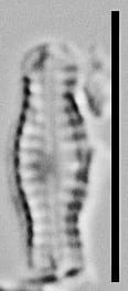
Description
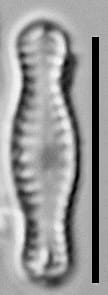
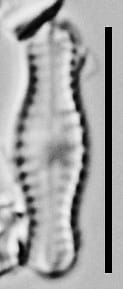
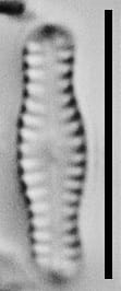
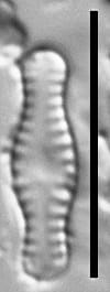
Valves are linear, with a distinct central expansion. Apices are subcapitate to capitate. The axial area is narrow and linear, expanding slightly toward the center of the valve. The central area is indistinct. The striae are slightly radiate at the center of the valve, transitioning to parallel to slightly convergent at the apices. The raphe is filiform, with relatively widely spaced proximal raphe ends.
Autecology
Chamaepinnularia hassiaca is a freshwater and aerophytic species (Wetzel et. al. 2013), reported in Europe from streams with siliceous substrata (Lange-Bertalot et al. 2017). We verified C. hassiaca from streams in the southeast U.S. and lakes in the northeast U.S.
-
Size Range, µm3
-
Motility
-
Attachment
-
Habitat
-
Colony
-
Occurrence
-
Waterbody
-
Distribution
- Learn more about this
Original Description
132. N. Hassiaca nov. spec. –Tafel II, F. 26.—Schalen linear, an den Enden und in der Mitte angeschwollen. Raphe sehr zart. Streifen leicht strahlend, randständig, eine breite lanzettliche Area freilassend, ziemlich kräftig, 16-18 in 10 μ. Länge 12 μ, Breite 3 μ. Selten. Zwischen *Sphagnum* bei Vockerode.
-
BasionymNavicula hassiaca
-
AuthorKrasske 1925
-
Length Range12 µm
-
Width3 µm
-
Striae in 10µm16-18
Original Images


Citations & Links
Citations
-
Publication Link: 10.1080/0269249X.2009.9705793
Links
-
Index Nominum Algarum
Cite This Page
Polaskey, M. (2018). Chamaepinnularia hassiaca. In Diatoms of North America. Retrieved May 21, 2026, from https://diatoms.org/species/93543/chamaepinnularia-hassiaca
Responses
The 15 response plots show an environmental variable (x axis) against the relative abundance (y axis) of Chamaepinnularia hassiaca from all the stream reaches where it was present. Note that the relative abundance scale is the same on each plot. Explanation of each environmental variable and units are as follows:
ELEVATION = stream reach elevation (meters)
STRAHLER = distribution plot of the Strahler Stream Order
SLOPE = stream reach gradient (degrees)
W1_HALL = an index that is a measure of streamside (riparian) human activity that ranges from 0 - 10, with a value of 0 indicating of minimal disturbance to a value of 10 indicating severe disturbance.
PHSTVL = pH measured in a sealed syringe sample (pH units)
log_COND = log concentration of specific conductivity (µS/cm)
log_PTL = log concentration of total phosphorus (µg/L)
log_NO3 = log concentration of nitrate (µeq/L)
log_DOC = log concentration of dissolved organic carbon (mg/L)
log_SIO2 = log concentration of silicon (mg/L)
log_NA = log concentration of sodium (µeq/L)
log_HCO3 = log concentration of the bicarbonate ion (µeq/L)
EMBED = percent of the stream substrate that is embedded by sand and fine sediment
log_TURBIDITY = log of turbidity, a measure of cloudiness of water, in nephelometric turbidity units (NTU).
DISTOT = an index of total human disturbance in the watershed that ranges from 1 - 100, with a value of 0 indicating of minimal disturbance to a value of 100 indicating severe disturbance.
Chamaepinnularia hassiaca
- Valves small
- Central expansion
- Ends subcapitate to capitate
Valves are small, with a central expansion and subcapitate to capitate ends.