Home
Practitioners
Morphology
All Morphological Groups
Centric
Araphid
Eunotioid
Symmetric Biraphid
Monoraphid
Asymmetric Biraphid
Epithemioid
Nitzschioid
Surirelloid
Genera
Species
Glossary
About
About
News
Projects
Mission
Board of Directors
Editorial Review Board
Taxon Contributors
Contact Us
What are diatoms?
Donate
Search
×
Diatoms of North America
Practitioners
Morphology
Centric
Araphid
Eunotioid
Symmetric Biraphid
Monoraphid
Asymmetric Biraphid
Epithemioid
Nitzschioid
Surirelloid
Genera
Species
Glossary
About
News
Projects
Mission
Board of Directors
Editorial Review Board
Taxon Contributors
Contact Us
What are diatoms?
Donate
Search taxa, citations, glossary, contributors, and images
Submit
Close search
Return to overview
Images of
Eunotia
obliquestriata
Furey, R.L.Lowe and J.R.Johans. 2011
Type Specimen
Slide Number
ANSP GC M-4200
Site ID
GSM_10_15_05
Site Name
Soil seep Hungary Ridge Trail, Great Smoky Mountains National Park
Coordinates
35.50917, -83.84389
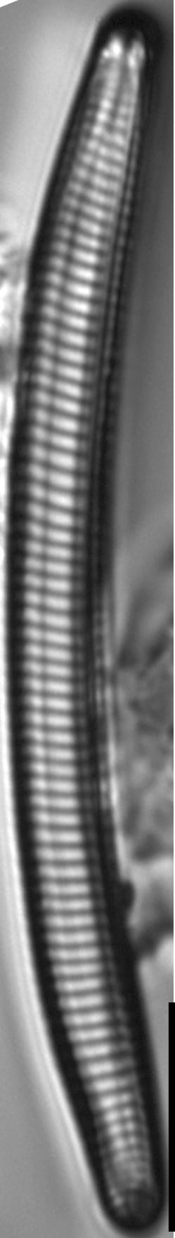
Caption
type material
Notes
Co-ordinates unavailable, but the site is located a 20 minute walk up the Hungry Ridge Trail after leaving the 20 – Mile Creek Trail.
Scalebar = 10 µm
Slide Number
ANSP GC M-4200
Site ID
GSM_10_15_05
Site Name
Soil seep Hungary Ridge Trail, Great Smoky Mountains National Park
Coordinates
35.50917, -83.84389
Caption
Type material
Notes
Co-ordinates unavailable, but the site is located a 20 minute walk up the Hungry Ridge Trail after leaving the 20 – Mile Creek Trail.
Scalebar = 10 µm
Slide Number
CAS 222085
Site ID
GSM_10_15_05
Site Name
Soil seep Hungary Ridge Trail, Great Smoky Mountains National Park
Coordinates
35.50917, -83.84389
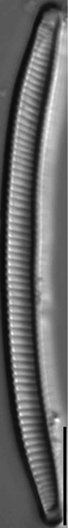
Caption
Isotype
Notes
Co-ordinates unavailable, but the site is located a 20 minute walk up the Hungry Ridge Trail after leaving the 20 – Mile Creek Trail.
Scalebar = 10 µm
Slide Number
ANSP GC 58627
Site ID
GSM_10_15_05
Site Name
Soil seep Hungary Ridge Trail, Great Smoky Mountains National Park
Coordinates
35.50917, -83.84389
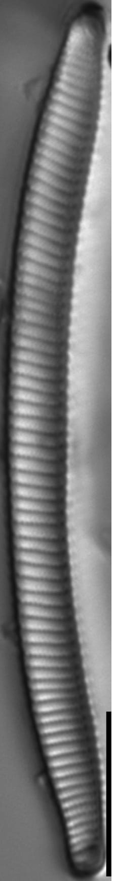
Caption
Holotype
Notes
Co-ordinates unavailable, but the site is located a 20 minute walk up the Hungry Ridge Trail after leaving the 20 – Mile Creek Trail.
Scalebar = 10 µm
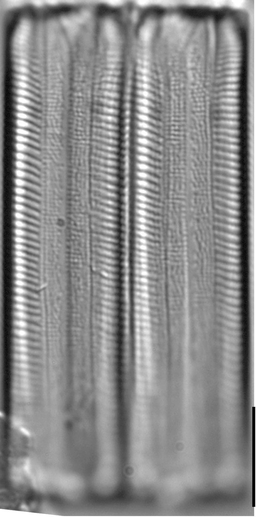
Slide Number
ANSP GC M-4200
Site ID
GSM_10_15_05
Site Name
Soil seep Hungary Ridge Trail, Great Smoky Mountains National Park
Coordinates
35.50917, -83.84389
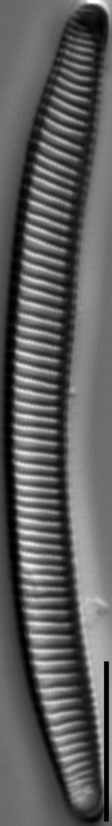
Caption
Girdle view: 2 frustules; type material
Notes
Co-ordinates unavailable, but the site is located a 20 minute walk up the Hungry Ridge Trail after leaving the 20 – Mile Creek Trail.
Scalebar = 10 µm
Site ID
GSM_10_15_05
Name
Soil seep Hungary Ridge Trail, Great Smoky Mountains National Park
Coordinates
35.50917, -83.84389
Caption
Internal view showing striae and one helictoglossa.
Notes
Co-ordinates unavailable, but the site is located a 20 minute walk up the Hungry Ridge Trail after leaving the 20 – Mile Creek Trail.
Scalebar = 5 µm
Site ID
GSM_10_15_05
Name
Soil seep Hungary Ridge Trail, Great Smoky Mountains National Park
Coordinates
35.50917, -83.84389
Caption
External girdle view
Notes
Co-ordinates unavailable, but the site is located a 20 minute walk up the Hungry Ridge Trail after leaving the 20 – Mile Creek Trail.
Scalebar = 5 µm