Navicula viridula

-
Category
-
Length Range50-70 µm
-
Width Range11.2-13.5 µm
-
Striae in 10 µm8-9
-
ContributorMarina Potapova - Nov 2011
-
ReviewerRex Lowe - Nov 2011
Identification


Description
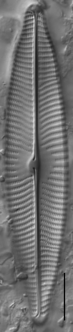
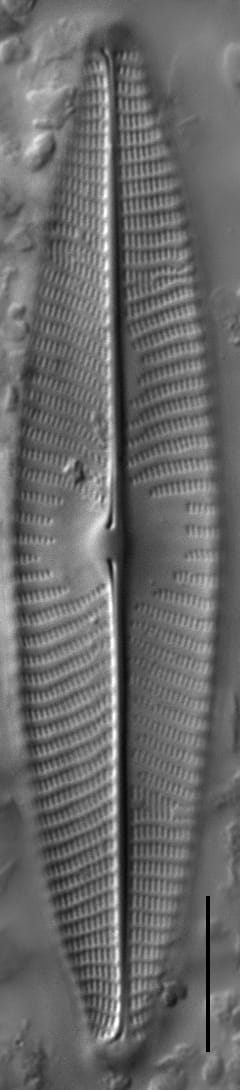
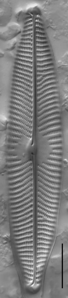
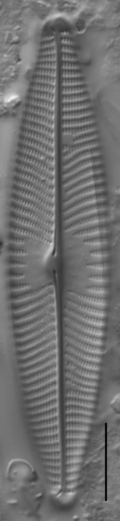
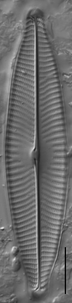
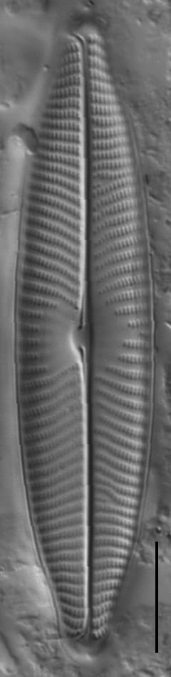
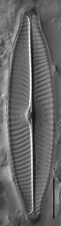
Valves are lanceolate to linear-lanceolate with subrostrate apices. The axial area is narrow and straight. The central area is asymmetric; it is trapezoid on the primary side, and semi-circular on the secondary side. The raphe is straight, with external proximal raphe ends slightly dilated and bent toward the primary side of the valve. The central nodule is asymmetrically expanded on the internal valve surface to the primary side. Striae are radiate in the valve center, becoming convergent at the apices. Areolae are usually visible under LM and number 24-25 in 10 μm.
Autecology
This taxon is most abundant in low gradient streams and rivers, where fine sediments are prevalent. It is tolerant of high pH, conductance, and alkalinity. It is found across a range of nitrogen concentrations and high phosphorus.
-
Size Range, µm3
-
Motility
-
Attachment
-
Habitat
-
Colony
-
Occurrence
-
BCG
-
Waterbody
-
Distribution
- Learn more about this
Original Description
FRUSTULIA VIRIDULA. Ktz. (Fig. 12.) Frustulis minutissimis viridi-lutescentibus, lanceolatis, altero latere truncates, altero acutiusculis, aut opacis aut apicibus hyalines, in strato mucoso nidulantibus. Ich fand sie in einem Teiche bei Markwerben unweit Weissenfels an Hypnum fluitans, so wie auch unter Oscillatorien, mit der folgenden vermischt. Sie bewegte sich.
-
BasionymFrustulia viridula
-
AuthorKütz. 1833
Original Images


Citations & Links
Citations
Links
-
Index Nominum Algarum
-
GenBank
-
North American Diatom Ecological DatabaseNADED ID: 46408
-
Hustedt Collection
Cite This Page
Potapova, M. (2011). Navicula viridula. In Diatoms of North America. Retrieved July 27, 2026, from https://diatoms.org/species/47098/navicula_viridula
Responses
The 15 response plots show an environmental variable (x axis) against the relative abundance (y axis) of Navicula viridula from all the stream reaches where it was present. Note that the relative abundance scale is the same on each plot. Explanation of each environmental variable and units are as follows:
ELEVATION = stream reach elevation (meters)
STRAHLER = distribution plot of the Strahler Stream Order
SLOPE = stream reach gradient (degrees)
W1_HALL = an index that is a measure of streamside (riparian) human activity that ranges from 0 - 10, with a value of 0 indicating of minimal disturbance to a value of 10 indicating severe disturbance.
PHSTVL = pH measured in a sealed syringe sample (pH units)
log_COND = log concentration of specific conductivity (µS/cm)
log_PTL = log concentration of total phosphorus (µg/L)
log_NO3 = log concentration of nitrate (µeq/L)
log_DOC = log concentration of dissolved organic carbon (mg/L)
log_SIO2 = log concentration of silicon (mg/L)
log_NA = log concentration of sodium (µeq/L)
log_HCO3 = log concentration of the bicarbonate ion (µeq/L)
EMBED = percent of the stream substrate that is embedded by sand and fine sediment
log_TURBIDITY = log of turbidity, a measure of cloudiness of water, in nephelometric turbidity units (NTU).
DISTOT = an index of total human disturbance in the watershed that ranges from 1 - 100, with a value of 0 indicating of minimal disturbance to a value of 100 indicating severe disturbance.
Navicula viridula
- Valves lanceolate to linear-lanceolate
- Apices subrostrate
- Valves 11.2-13.5 μm wide
- Central nodule asymmmetric
- External proximal raphe ends bent toward primary side
Valves are lanceolate to linear-lanceolate with subrostrate apices. Central area is asymmetric; trapezoid on primary side, semi-circular on secondary side. External proximal raphe ends are slightly dilated and bent toward the primary side of the valve. The central nodule is asymmetrically expanded on the internal valve surface to the...