Nitzschia fonticola

-
Category
-
Length Range10-55 µm
-
Width Range2.5-4.5 µm
-
Striae in 10 µm24-27
-
SynonymsNitzschia fonticola Grunow in Cleve and J.D.Möller 1879
Nitzschia palea var. fonticola Grunow 1880
-
Reported AsNitzschia tropica (Hustedt 1949 pg. 147, pl. 11, figs 34-38)
Nitzschia romana (Hustedt 1930 pg. 415)
-
ContributorPat Kociolek - Sep 2011
-
ReviewerSarah Spaulding - Mar 2014
Identification
Description
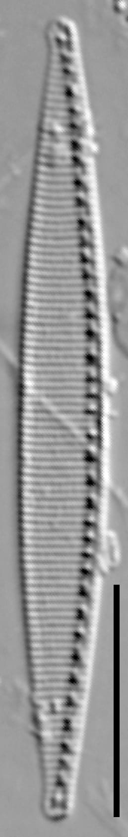
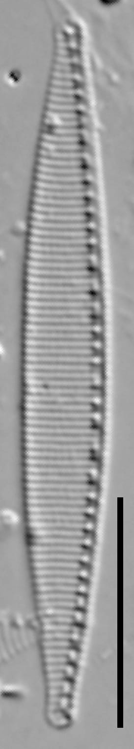
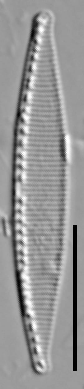
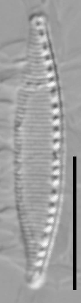
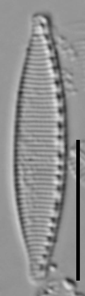
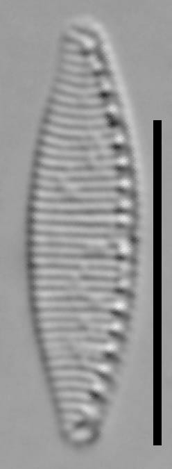
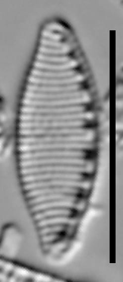
Valves are broadly lanceolate, with curved margins that taper to narrow ends. The apices are knob-like and rounded. Striae are distinct and parallel. The keel is eccentric. Fibulae are distinct and number 10-13 in 10 µm. There is prominent gap in the central fibulae (often termed the 'central nodule' within the genus Nitzschia).
We observed a smaller size range of this taxon than the range reported by Krammer and Lange-Bertalot (1988).
This taxon is treated as Nitzschia romana Grunow by Hustedt (1930, p. 415).
Nitzschia fonticola has been confused with N. tropica Hustedt. The name N. tropica has been applied, incorrectly, to populations of N. fonticola from North America. Nitzschia tropica, however, was described from the former Belgian Congo, Africa. Nitzschia tropica is more linear and has a straight raphe (Simonsen 1987; Krammer and Lange-Bertalot 1988). To date, Nitzschia tropica has not been verified from collections in North America.
Autecology
This taxon is widely distributed in the United States, particularly in rivers that are relatively high in specific conductance and fine sediment. Within California, this taxon is classified as a species that is found in rivers that are impacted by human influences.
-
Size Range, µm3
-
Motility
-
Attachment
-
Habitat
-
Colony
-
Occurrence
-
BCG
-
Waterbody
-
Distribution
- Learn more about this
Original Description
-
BasionymNitzschia palea var. fonticola
-
AuthorGrunow 1880
Citations & Links
Citations
Links
-
Index Nominum Algarum
-
GenBank
-
North American Diatom Ecological DatabaseNADED ID: 48011
Cite This Page
Kociolek, P. (2011). Nitzschia fonticola. In Diatoms of North America. Retrieved August 03, 2026, from https://diatoms.org/species/46723/nitzschia_fonticola
Responses
The 15 response plots show an environmental variable (x axis) against the relative abundance (y axis) of Nitzschia fonticola from all the stream reaches where it was present. Note that the relative abundance scale is the same on each plot. Explanation of each environmental variable and units are as follows:
ELEVATION = stream reach elevation (meters)
STRAHLER = distribution plot of the Strahler Stream Order
SLOPE = stream reach gradient (degrees)
W1_HALL = an index that is a measure of streamside (riparian) human activity that ranges from 0 - 10, with a value of 0 indicating of minimal disturbance to a value of 10 indicating severe disturbance.
PHSTVL = pH measured in a sealed syringe sample (pH units)
log_COND = log concentration of specific conductivity (µS/cm)
log_PTL = log concentration of total phosphorus (µg/L)
log_NO3 = log concentration of nitrate (µeq/L)
log_DOC = log concentration of dissolved organic carbon (mg/L)
log_SIO2 = log concentration of silicon (mg/L)
log_NA = log concentration of sodium (µeq/L)
log_HCO3 = log concentration of the bicarbonate ion (µeq/L)
EMBED = percent of the stream substrate that is embedded by sand and fine sediment
log_TURBIDITY = log of turbidity, a measure of cloudiness of water, in nephelometric turbidity units (NTU).
DISTOT = an index of total human disturbance in the watershed that ranges from 1 - 100, with a value of 0 indicating of minimal disturbance to a value of 100 indicating severe disturbance.
Nitzschia fonticola
- Valves broadly lanceolate with parallel margins
- Apices rounded, knob-like
- Prominent gap in central fibulae
Valves broadly lanceolate with parallel margins. Valve ends with knob-like, rounded apices. Prominent gap in central fibulae (central nodule present). Striae are distinct.