Planothidium lanceolatoides

-
Category
-
Length Range17-36 µm
-
Width Range9-13 µm
-
Striae in 10 µm11-14
-
SynonymsAchnanthes lanceolata var. lanceolatoides (Sovereign) Reimer in R.M.Patrick and Reimer
-
ContributorMarina Potapova - Apr 2015
-
ReviewerIonel Ciugulea - Mar 2019
Identification


Description
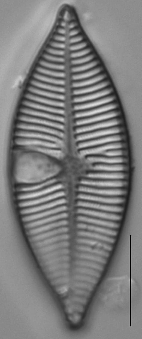
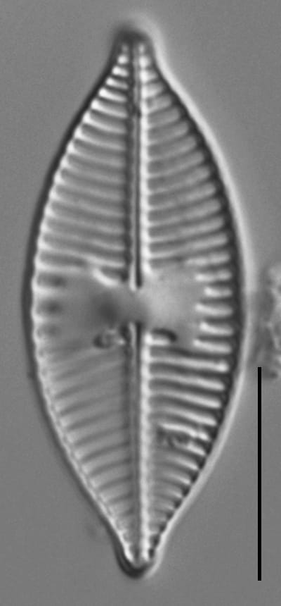
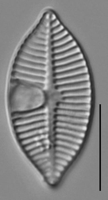
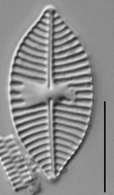
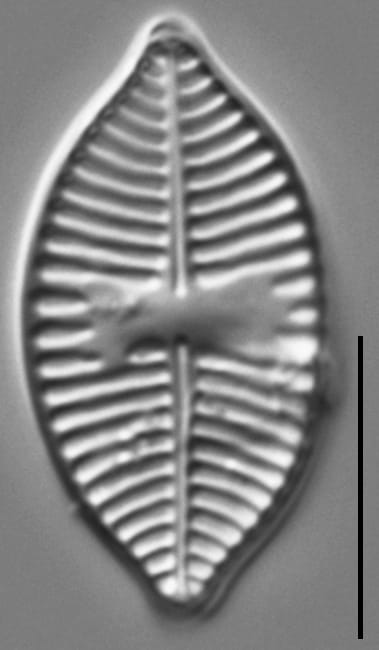
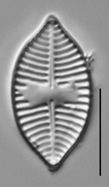
Valves are lanceolate with apiculate apices. On the raphe valve, the axial area is linear. The raphe is straight, with expanded external proximal ends. Terminal raphe fissures are curved to the secondary valve side. The central area variable, ranging from rectangular to bow tie-shaped. Striae delimiting the central are often interrupted. As a result, the central area on some specimens appear to have 1-4 dash-like marks. Striae are multiseriate.
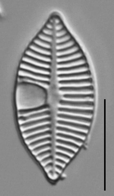
On the rapheless valve, the axial area is linear. The central area is asymmetric, with one side of the central area expanded to the valve margin. On the internal valve surface, this expanded central area contains a cavum. Striae are biseriate in the middle part of the valve and closer to the axial area, but become triseriate toward the margin and valve ends. Near the valve ends the striae may contain more than three rows of areolae.
Autecology
To date, this taxon is known only from the Pacific Northwest. It was originally described from Diamond Lake, Oregon in waters of pH 8.1-8.8 (Sovereign 1958). It was noted as being very rare within samples. The images presented here were collected in the North Umpqua River, Oregon.
-
Size Range, µm3
-
Motility
-
Attachment
-
Habitat
-
Colony
-
Occurrence
-
Waterbody
- Learn more about this
Original Description
Achnanthes lanceolatoides sp. nov. Pl. II, Figs. 18, 19.
Valvae elliptico-lanecolatae apicibus acutis, subrostratis, 22-35 µ longae, 10-12 µ latae: rhaphovalva rhaphe directa filiformi, area axiali angusta, area centrali transapicaliter dilata, subrectangulata, membrana valde transpicaliter costata, costae radiantes, 11-14 in 10 µ, intervalla delicatissime areolata; areovalva area axiali anguste lanceolata, area centrali parva, uno latere area hyaline soleae equinae ad instar; costae transpicales radiantes 11-13 in 10µ, intervalla delicatissime areolata, punctis minimis in seribus duabus alternatim postis.
This species is related to A. lanceolata (Bréb.) Grun. but is easily separated from that species by its coarser structure and the thickening, and generally shortening of the striae bordering the central area of the raphe valve. It has been found thus far only in Diamond Lake and is scarce in both samples; in water with pH 8.1 to 8.8
-
BasionymAchnanthes lancelatoides
-
AuthorSovereign 1958
-
Length Range22-35 µm
-
Width10-12 µm
-
Striae in 10µm11-14
Original Images


Citations & Links
Citations
Links
Cite This Page
Potapova, M. (2015). Planothidium lanceolatoides. In Diatoms of North America. Retrieved June 10, 2026, from https://diatoms.org/species/50373/planothidium_lanceolatoides
Responses
The 15 response plots show an environmental variable (x axis) against the relative abundance (y axis) of Planothidium lanceolatoides from all the stream reaches where it was present. Note that the relative abundance scale is the same on each plot. Explanation of each environmental variable and units are as follows:
ELEVATION = stream reach elevation (meters)
STRAHLER = distribution plot of the Strahler Stream Order
SLOPE = stream reach gradient (degrees)
W1_HALL = an index that is a measure of streamside (riparian) human activity that ranges from 0 - 10, with a value of 0 indicating of minimal disturbance to a value of 10 indicating severe disturbance.
PHSTVL = pH measured in a sealed syringe sample (pH units)
log_COND = log concentration of specific conductivity (µS/cm)
log_PTL = log concentration of total phosphorus (µg/L)
log_NO3 = log concentration of nitrate (µeq/L)
log_DOC = log concentration of dissolved organic carbon (mg/L)
log_SIO2 = log concentration of silicon (mg/L)
log_NA = log concentration of sodium (µeq/L)
log_HCO3 = log concentration of the bicarbonate ion (µeq/L)
EMBED = percent of the stream substrate that is embedded by sand and fine sediment
log_TURBIDITY = log of turbidity, a measure of cloudiness of water, in nephelometric turbidity units (NTU).
DISTOT = an index of total human disturbance in the watershed that ranges from 1 - 100, with a value of 0 indicating of minimal disturbance to a value of 100 indicating severe disturbance.
Planothidium lanceolatoides
- Apices apiculate
- Valves 9-13 μm wide
- Rapheless valve with cavum
- Raphe valve with rectangular central area
Valves are lanceolate, with apiculate apices. Width ranges from 9-13 µm. The rapheless valve has a distinct cavum. The raphe valve has a nearly rectangular central area.