


Credit: Tom Frankovich
Living cell with chitin threads extending from fultoportulae. Okeechobee Waterway C44 canal, Indiantown, Florida, SLE2, plankton, Sep 12, 2019

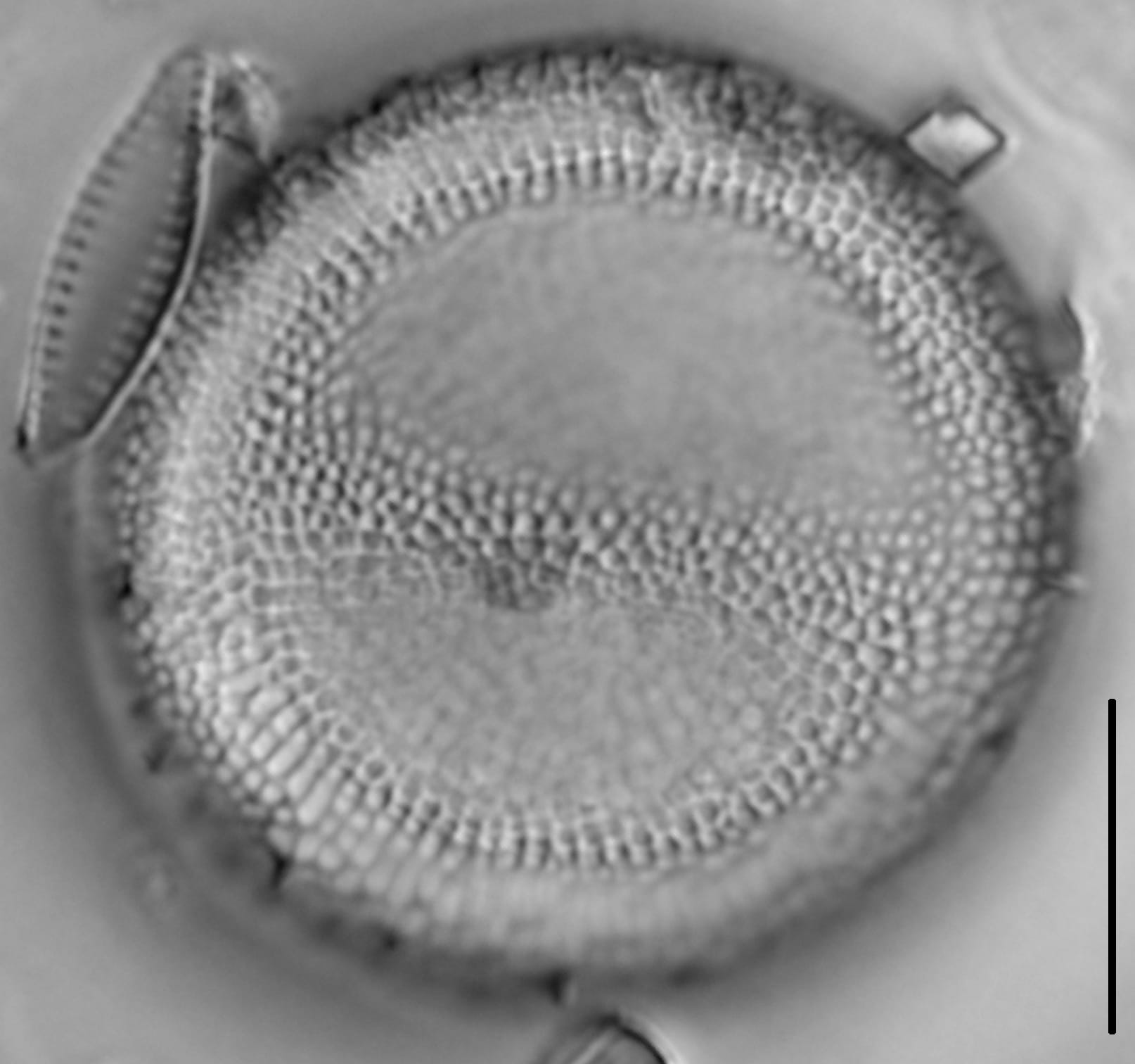
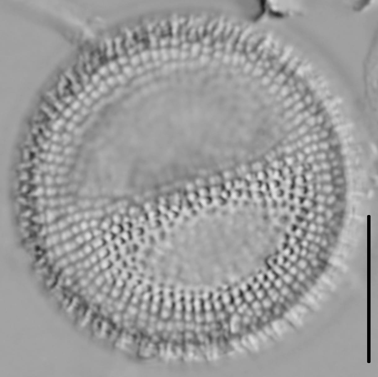
Valves are rounded and tangentially undulate on the valve face. Areolae are rectangular to irregular in shape and organized into radial rows of coarse striae that may appear slightly disorganized. A ring of marginal fultoportulae is present. These fultoportulae have external tubes, giving the impression of a ring of short spines around the valve periphery. A prominent rimoportula is present on the valve face, close to the margin.
This taxon has been misidentified as T. bramaputra, which has not been verified in North America. According to Smucker et al. (2008), Thalassiosira bramaputrae has two marginal rings of evenly spaced fultoportulae. In contrast, T. lacustris has one complete ring of marginal fultoportulae and an inner ring of irregularly spaced occluded processes. The inner ring of proccesses number about half the number of marginal fultoportulae.
Thalassiosira lacustris was reported in estuaries of San Francisco Bay (Mahood et al. 1986) and Chesapeake Bay (USEPA 1998). In freshwater, however, there is indication that T. lacustris was introduced through ballast water released by ships entering Lake Erie (summarized in Smucker et al. 2008).
Prior to Smucker et al. (2008) T. lacustris was not known from streams of the unglaciated Western Allegheny Plateau of southeastern Ohio. The region is highly forested, and also disturbed by surface coal mining and agriculture. Within these impacted shallow streams, T. lacustris was present in riffle habitats.
This taxon has been documented in the Sabine River, Texas; Mermentau River, Louisiana; San Francisco Bay, California; Monocacy River and Chesapeake Bay Maryland; Plum Creek which drains to Lake Erie in northeastern Ohio; and southeastern Ohio streams draining to the Ohio River, which flows to the Mississippi River and eventually the Gulf of Mexico (Smucker et al. 2008).


Practitioners called attention to Smucker et al. (2008), which documented the range of diameter as 11-57 µm. The page was updated to reflect that size range. From 2011 until 2021, a smaller size range of 13-32 µm appeared. Additional details of the morphology were updated. - S. Spaulding
Kociolek, P., Frankovich, T. (2011). Thalassiosira lacustris. In Diatoms of North America. Retrieved July 21, 2026, from https://diatoms.org/species/46465/thalassiosira_lacustris
The 15 response plots show an environmental variable (x axis) against the relative abundance (y axis) of Thalassiosira lacustris from all the stream reaches where it was present. Note that the relative abundance scale is the same on each plot. Explanation of each environmental variable and units are as follows:
ELEVATION = stream reach elevation (meters)
STRAHLER = distribution plot of the Strahler Stream Order
SLOPE = stream reach gradient (degrees)
W1_HALL = an index that is a measure of streamside (riparian) human activity that ranges from 0 - 10, with a value of 0 indicating of minimal disturbance to a value of 10 indicating severe disturbance.
PHSTVL = pH measured in a sealed syringe sample (pH units)
log_COND = log concentration of specific conductivity (µS/cm)
log_PTL = log concentration of total phosphorus (µg/L)
log_NO3 = log concentration of nitrate (µeq/L)
log_DOC = log concentration of dissolved organic carbon (mg/L)
log_SIO2 = log concentration of silicon (mg/L)
log_NA = log concentration of sodium (µeq/L)
log_HCO3 = log concentration of the bicarbonate ion (µeq/L)
EMBED = percent of the stream substrate that is embedded by sand and fine sediment
log_TURBIDITY = log of turbidity, a measure of cloudiness of water, in nephelometric turbidity units (NTU).
DISTOT = an index of total human disturbance in the watershed that ranges from 1 - 100, with a value of 0 indicating of minimal disturbance to a value of 100 indicating severe disturbance.