Denticula kuetzingii

-
Category
-
Length Range20.5-28.3 µm
-
Width Range4.5-5.7 µm
-
Striae in 10 µm17-19
-
Reported AsDiatoma obtusum (Kirchner 1878, pg. 204)
Denticula kuetzingii (Krammer and Lange-Bertalot 1988, Pl 99 Fig 11-23 Pl 100 Fig 1-14)
-
ContributorJoe Mohan - Aug 2022
-
ReviewerDavid R.L. Burge - Dec 2022
Identification
Description
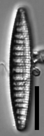
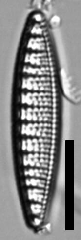
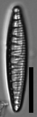
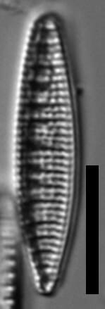
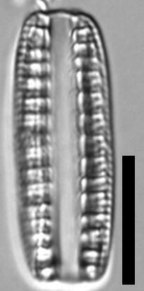
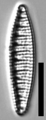
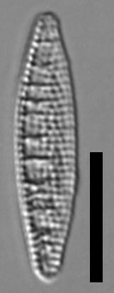
Valves are narrow and lanceolate with sub-rostrate apices. Striae are parallel throughout. Areolae are equally spaced, clearly separated, and number 10-12 in 10 μm. The raphe is eccentric and supported by fibulae that extend transapically from the center of the valve. Fibulae extend internally at irregular angles from the raphe to about halfway across the valve face.
Grunow (1862) reported the dimensions as 29-30 μm long and 4 μm wide.
Autecology
This taxon has been found in fresh to brackish water. It has been reported Lake Superior and Shell Lake in Sleeping Bear Dunes National Lakeshore in Michigan (specimens illustrated here). It was reported from 15 lakes in the Sand Hills of Nebraska, preferring deeper lakes with a nitrate + nitrite optimum of 513 μg/L, total phosphorus optimum of 29 μg/L, and an alkalinity optimum of 173 mg/L (Shinneman et al. 2010).
This taxon was also reported living in brackish water in Kongsfjorden, Svalbard (Al-Handal et al. 2016).
-
Size Range, µm3
-
Motility
-
Attachment
-
Habitat
-
Colony
-
Occurrence
-
BCG
-
Waterbody
-
Distribution
- Learn more about this
Original Description
-
AuthorGrunow 1862
-
Length Range29-30 µm
-
Striae in 10µm36-40
Original Images


Citations & Links
Citations
-
Publication Link: https://doi.org/10.1007/s00300-016-1998-7
-
Publication Link: 10.1007/s10933-010-9427-3
Cite This Page
Mohan, J. (2022). Denticula kuetzingii. In Diatoms of North America. Retrieved April 04, 2026, from https://diatoms.org/species/61786/denticula-kuetzingii
Responses
The 15 response plots show an environmental variable (x axis) against the relative abundance (y axis) of Denticula kuetzingii from all the stream reaches where it was present. Note that the relative abundance scale is the same on each plot. Explanation of each environmental variable and units are as follows:
ELEVATION = stream reach elevation (meters)
STRAHLER = distribution plot of the Strahler Stream Order
SLOPE = stream reach gradient (degrees)
W1_HALL = an index that is a measure of streamside (riparian) human activity that ranges from 0 - 10, with a value of 0 indicating of minimal disturbance to a value of 10 indicating severe disturbance.
PHSTVL = pH measured in a sealed syringe sample (pH units)
log_COND = log concentration of specific conductivity (µS/cm)
log_PTL = log concentration of total phosphorus (µg/L)
log_NO3 = log concentration of nitrate (µeq/L)
log_DOC = log concentration of dissolved organic carbon (mg/L)
log_SIO2 = log concentration of silicon (mg/L)
log_NA = log concentration of sodium (µeq/L)
log_HCO3 = log concentration of the bicarbonate ion (µeq/L)
EMBED = percent of the stream substrate that is embedded by sand and fine sediment
log_TURBIDITY = log of turbidity, a measure of cloudiness of water, in nephelometric turbidity units (NTU).
DISTOT = an index of total human disturbance in the watershed that ranges from 1 - 100, with a value of 0 indicating of minimal disturbance to a value of 100 indicating severe disturbance.
Denticula kuetzingii
- Valves lanceolate
- Raphe positioned on valve margin
- Fibulae extend halfway across valve
Valves are lanceolate. The raphe is eccentric, positioned on the valve margin. Fibulae extend halfway across the valve face.