

Credit: USGS Biodata
The distribution of Eunotia zasuminensis in rivers of the United States. Accessed on July 5, 2017


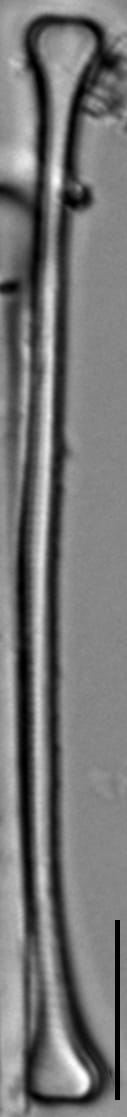
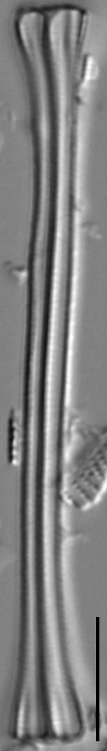
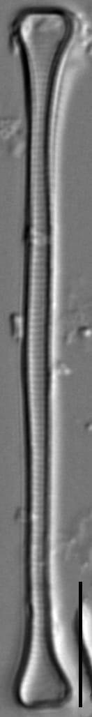
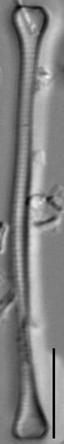
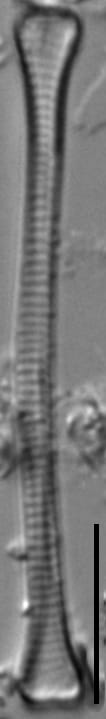
Valves linear and elongate, weakly dorsiventral. The dorsal margin is slightly convex and the ventral margin is slightly concave giving the valves slight asymmetry appearance to the apical axis. Valves can sometimes be irregularly wavy. Apices capitate, 3.5-4.0 µm wide, ending truncate. Raphe short, present on the ventral face-mantle junction on the ventral side of each valve end. The transapical striae are parallel throughout. In girdle view the valves are often not straight and the apices are expanded in the pervalvar axis.
Eunotia zasuminensis is reported from low alkalinity and dystrophic lakes of the Adirondacks. In lakes of Finland, E. zasuminensis forms zig-zag to stellate colonies and was most abundant in the summer months of July and August (Eloranta 1986). In addition to being reported in lakes, this taxon has also been reported from large rivers in the Amazon River Basin (Wetzel et al. 2010). Material illustrated here is from boreal lakes in northern Minnesota (Voyageurs National Park) and was collected as part of the National Park Service Great Lakes Inventory and Monitoring Network.
Burge, D., Edlund, M. (2017). Eunotia zasuminensis. In Diatoms of North America. Retrieved July 25, 2026, from https://diatoms.org/species/52434/eunotia_zasuminensis
The 15 response plots show an environmental variable (x axis) against the relative abundance (y axis) of Eunotia zasuminensis from all the stream reaches where it was present. Note that the relative abundance scale is the same on each plot. Explanation of each environmental variable and units are as follows:
ELEVATION = stream reach elevation (meters)
STRAHLER = distribution plot of the Strahler Stream Order
SLOPE = stream reach gradient (degrees)
W1_HALL = an index that is a measure of streamside (riparian) human activity that ranges from 0 - 10, with a value of 0 indicating of minimal disturbance to a value of 10 indicating severe disturbance.
PHSTVL = pH measured in a sealed syringe sample (pH units)
log_COND = log concentration of specific conductivity (µS/cm)
log_PTL = log concentration of total phosphorus (µg/L)
log_NO3 = log concentration of nitrate (µeq/L)
log_DOC = log concentration of dissolved organic carbon (mg/L)
log_SIO2 = log concentration of silicon (mg/L)
log_NA = log concentration of sodium (µeq/L)
log_HCO3 = log concentration of the bicarbonate ion (µeq/L)
EMBED = percent of the stream substrate that is embedded by sand and fine sediment
log_TURBIDITY = log of turbidity, a measure of cloudiness of water, in nephelometric turbidity units (NTU).
DISTOT = an index of total human disturbance in the watershed that ranges from 1 - 100, with a value of 0 indicating of minimal disturbance to a value of 100 indicating severe disturbance.