
Credit: R. A. Carlsen
Blodgett Lake in the Bitterroot Range, Selway-Bitterroot Wilderness, Ravalli County, Montana: home of Eunotia serra.

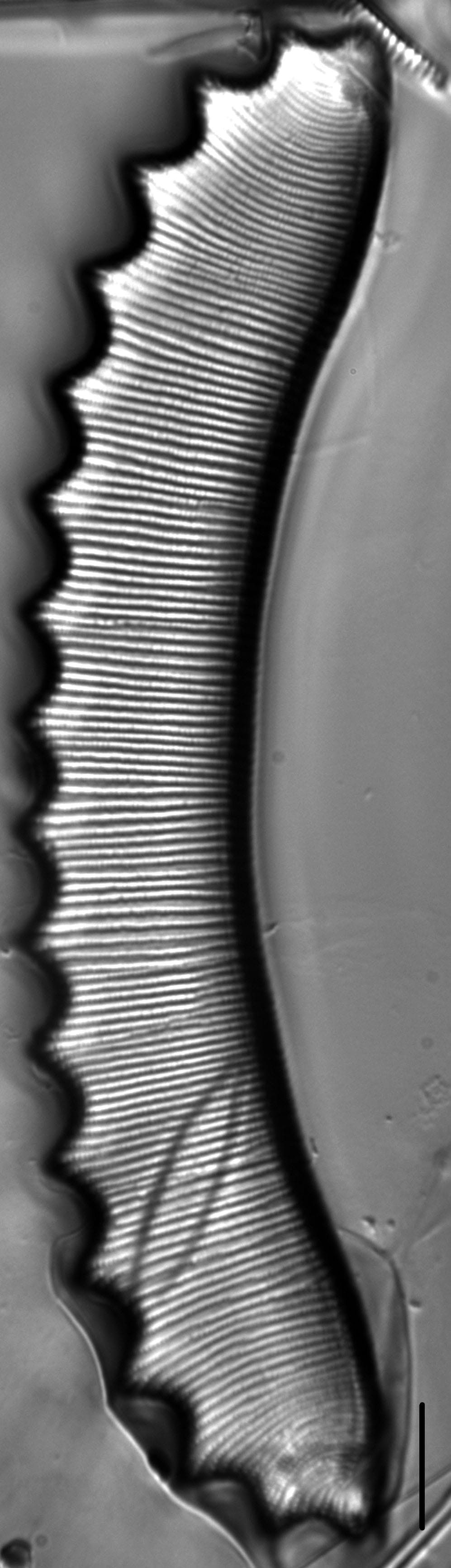
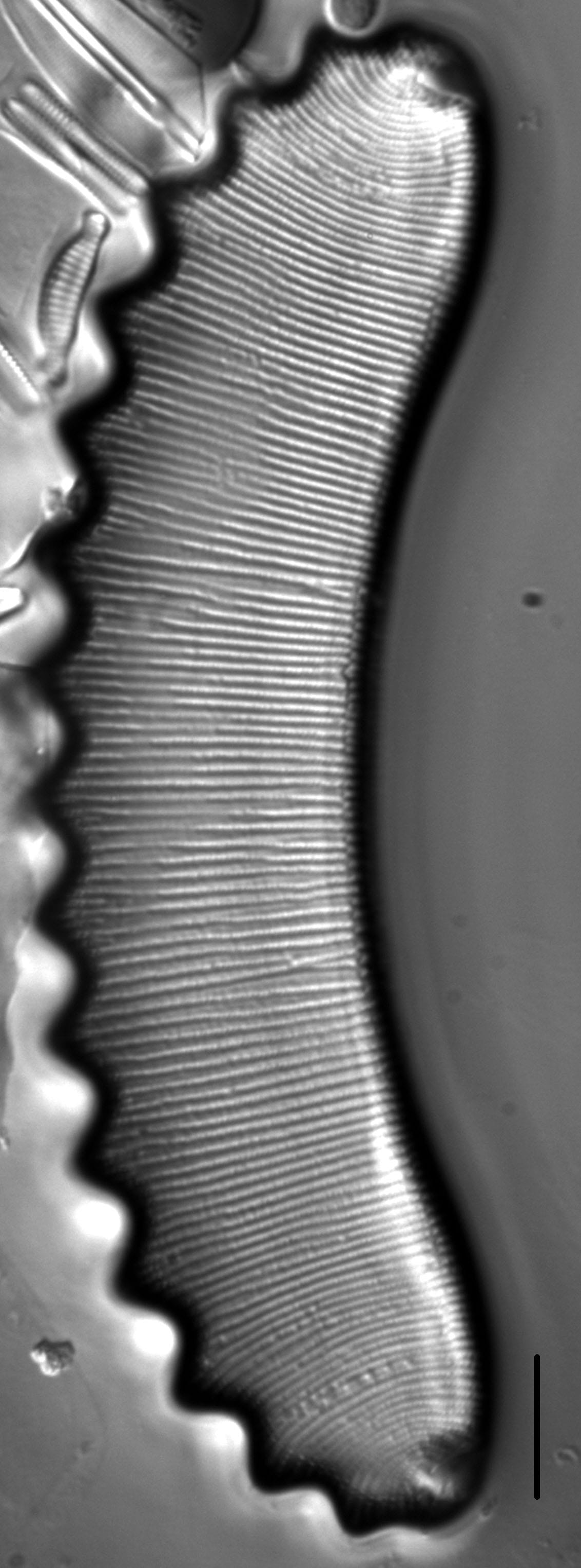
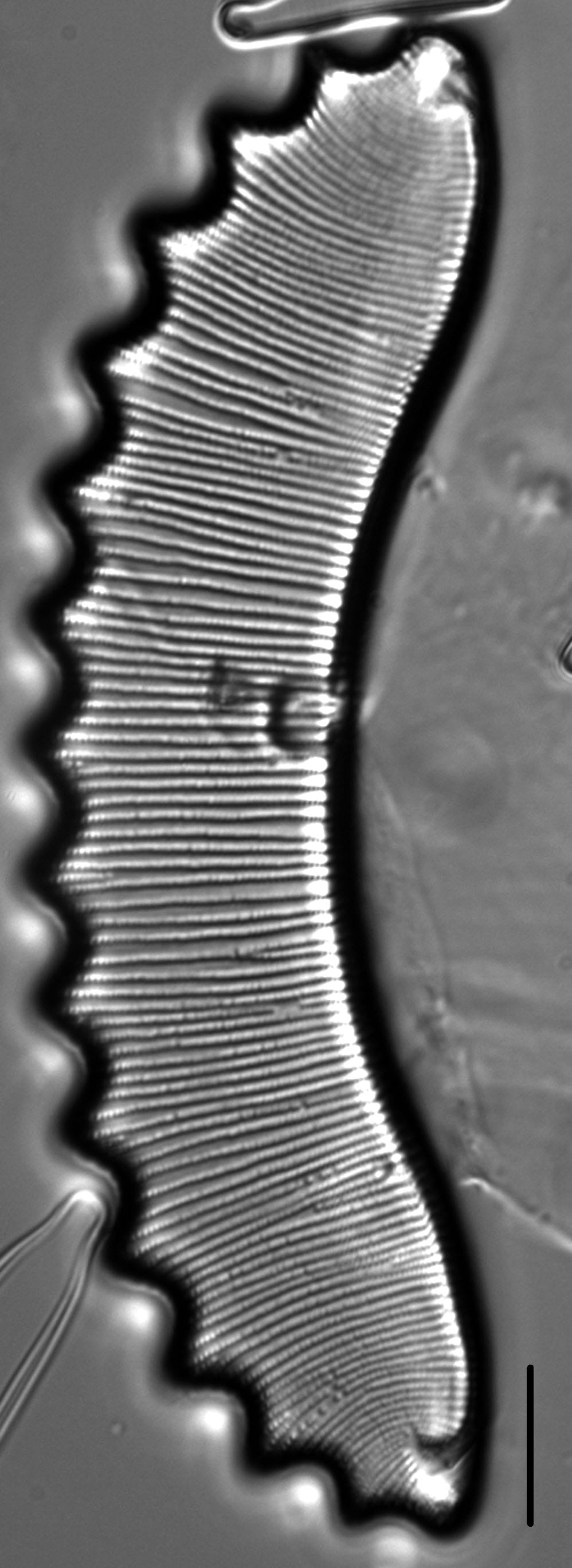
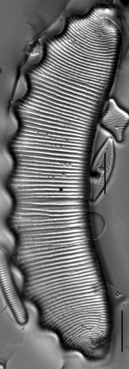
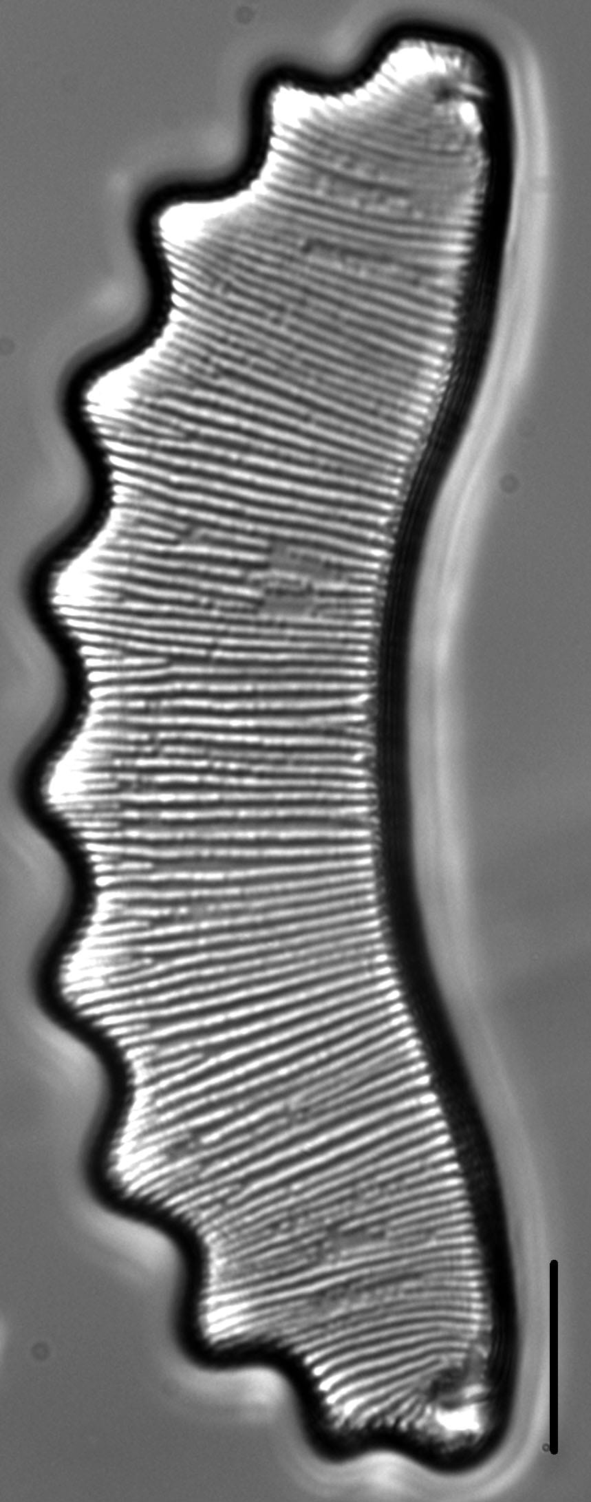
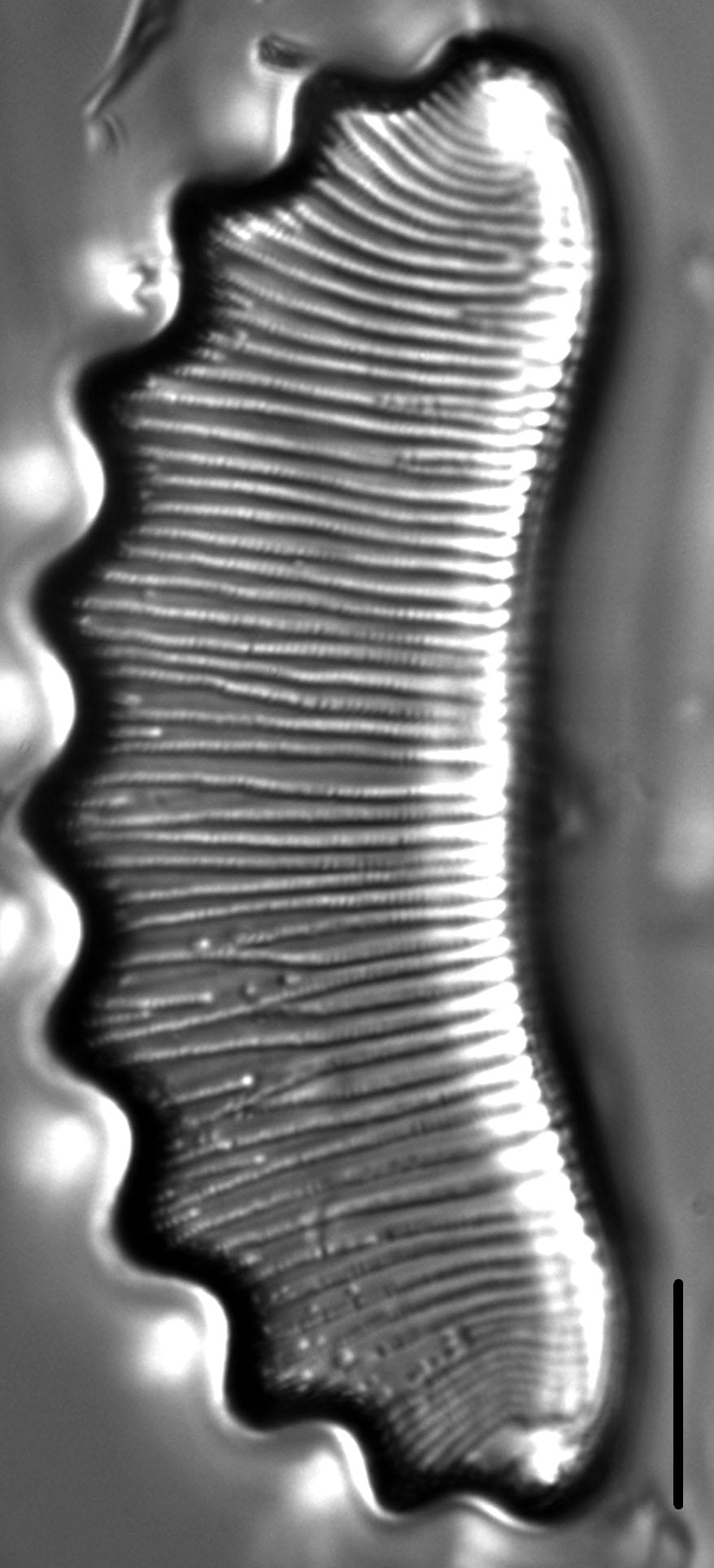
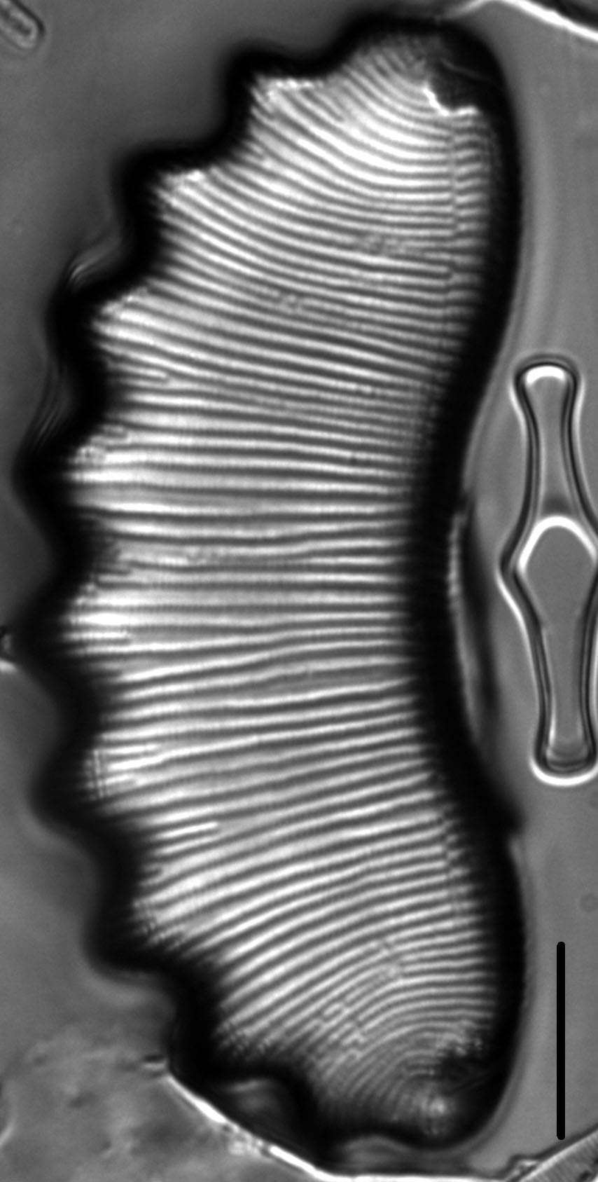
Valves are very large and highly arched. The dorsal margin has 9 to 16 bluntly pointed and evenly spaced undulations. The ventral margin is concave and follows the same curvature as the dorsal margin. Valve apices are about the same size and shape as the undulations (images 1 and 3). Occasionally a terminal undulation will coalesce with the apex, which then becomes much wider and obtusely rounded (images 2 and 7). Distal raphe ends terminate about two thirds of the way from the ventral to the dorsal margin and at some distance from the apex. Striae are radiate throughout and of two types: complete striae that extend the full width of the valve and short striae that occur only along the dorsal margin. Short dorsal striae are more frequent within the undulations, especially in smaller specimens. A fine transparent line runs along the ventral margin and ascends the valve face near the apices, where it angles towards the terminal nodules. Striae on either side of this line may be continuous or displaced. Areolae in the striae are 26-29 in 10 µm.
The number of dorsal undulations in other U.S. populations ranges from 6 to 22, valve length ranges from 40 to 165 µm, and valve width ranges from 13 to 18 µm (Brant & Furey 2011, P. C. Furey, pers. comm.). Montana specimens (18-24 µm wide) are wider than these and also wider than specimens reported from Europe (12-16 µm wide; Lange-Bertalot et al. 2011).
This taxon is broadly distributed (Lange-Bertalot et al. 2011) and has been reported with light micrographs from lakes in Alaska (Foged 1981), the Northeastern US (Camburn and Charles 2000), the Atlantic Coastal Plain (Siver and Hamilton 2011), the Rocky Mountains, Cascades, and Sierras (Bahls 2021). Lange-Bertalot et al. (2011) report this species as a component of the Holarctic flora of Eurasia and North America.
In the Great Lakes National Parks (Edlund et al. 2009, 2011, 2012, 2013), Eunotia serra is rare (0.1-1% abundance) at Voyageurs (Locator Lake).
It is reported to occur in mountainous lakes and ponds with cool, slightly to moderately acidic waters of very low conductivity (Lange-Bertalot et al. 2011, Bahls 2021). This taxon is reported to occur in oligotrophic to dystrophic systems (Lange Betalot et al. 2011). In the Northern Rockies, this taxon has been recorded from ponds and small lakes in the Bitterroot Range on the Montana/Idaho border. Here pH ranges from 5.5 to 6.5 and EC ranges from 5 to 27.
Several research groups consider this taxon an indicator organism and published regional environmental optima and tolerances including:
Camburn and Charles (2000): pH - 5.17 +/- 0.67, Acid Neutralizing Capacity - (-1) +/- 30 µeq/L, Total Aluminum - 120 +/- 153 µg/L, Dissolved Organic Carbon - 82 +/- 118 µmol/L, Total Phosphorus (TP) - 27.32 +/- 14.76 µg/L for populations from the Northeastern US.
Siver and Hamilton (2011): Abundance Weighted Mean (AWM) pH - 4.6 +/- 1.0, AWM TP - 16.9 +/- 10 µg/L for populations from the Atlantic Coastal Plain.
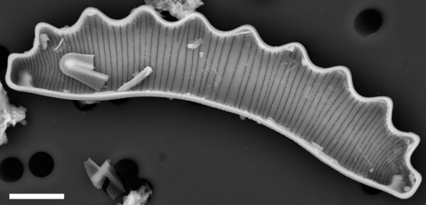
From 2012 until 2026 the autecological information on this taxon page was limited. As of this update, a SEM image, information on ecology, biogeography, and environmental optima have been added. - Lane Allen and Mark Edlund
Bahls, L., Edlund, M., Allen, L. (2012). Eunotia serra. In Diatoms of North America. Retrieved July 22, 2026, from https://diatoms.org/species/48502/eunotia_serra
The 15 response plots show an environmental variable (x axis) against the relative abundance (y axis) of Eunotia serra from all the stream reaches where it was present. Note that the relative abundance scale is the same on each plot. Explanation of each environmental variable and units are as follows:
ELEVATION = stream reach elevation (meters)
STRAHLER = distribution plot of the Strahler Stream Order
SLOPE = stream reach gradient (degrees)
W1_HALL = an index that is a measure of streamside (riparian) human activity that ranges from 0 - 10, with a value of 0 indicating of minimal disturbance to a value of 10 indicating severe disturbance.
PHSTVL = pH measured in a sealed syringe sample (pH units)
log_COND = log concentration of specific conductivity (µS/cm)
log_PTL = log concentration of total phosphorus (µg/L)
log_NO3 = log concentration of nitrate (µeq/L)
log_DOC = log concentration of dissolved organic carbon (mg/L)
log_SIO2 = log concentration of silicon (mg/L)
log_NA = log concentration of sodium (µeq/L)
log_HCO3 = log concentration of the bicarbonate ion (µeq/L)
EMBED = percent of the stream substrate that is embedded by sand and fine sediment
log_TURBIDITY = log of turbidity, a measure of cloudiness of water, in nephelometric turbidity units (NTU).
DISTOT = an index of total human disturbance in the watershed that ranges from 1 - 100, with a value of 0 indicating of minimal disturbance to a value of 100 indicating severe disturbance.