Brachysira follis
-
Category
-
Length Range30.5-48.8 µm
-
Width Range15.3-19.3 µm
-
Striae in 10 µm21-27
-
SynonymsAnomoeoneis follis (Ehrenb.) Cleve 1895
Navicula serians var. follis (Ehrenb.) Cleve and J.D.Möller 1879
-
Contributor
-
ReviewerSarah Spaulding - Jan 2019
Identification
Description
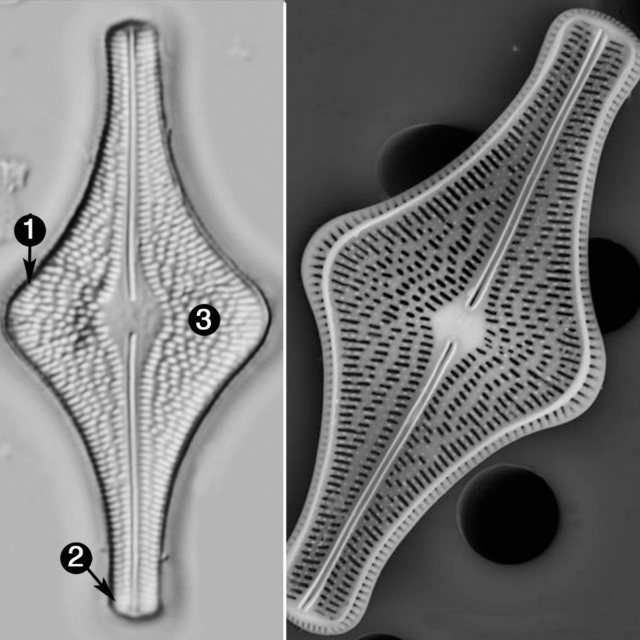
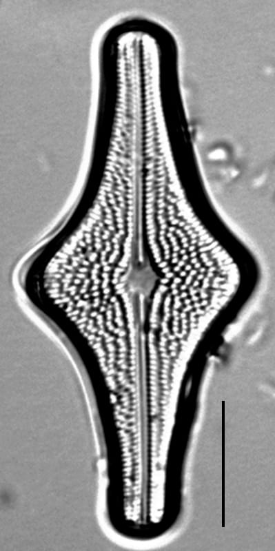
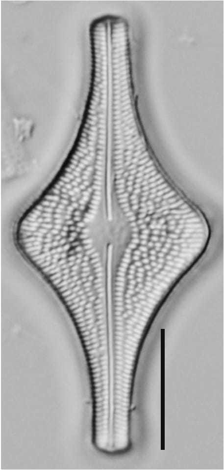
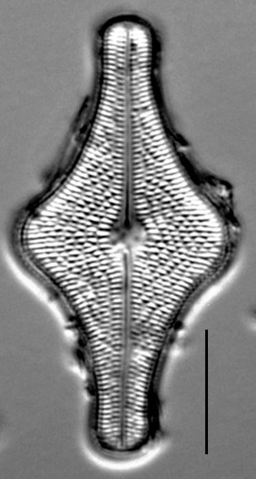
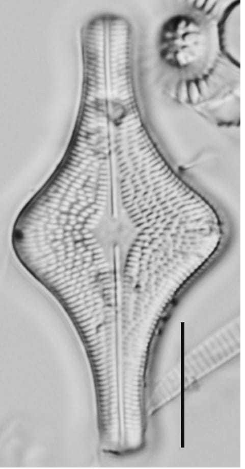
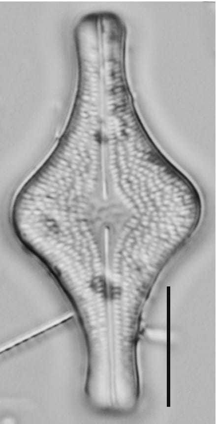
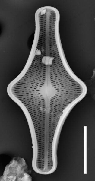
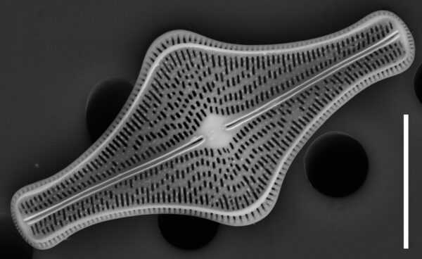
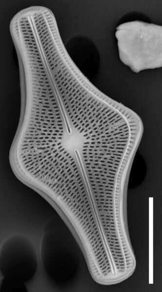
Valves are rhombic, with broadly rounded apices and an expanded mid valve. The axial area is narrow and straight. The raphe is straight and filiform. The central area is variable in shape and size. It may be round and symmetric, oval or diamond-shaped. Central striae are radiate, except at the ends of the valves where the striae become nearly parallel. There are a few shorter, irregular striae located on either side of the central area. Striae are formed by coarse puncta. Puncta increase in size near the valve margin.
Autecology
This taxon has a circumboreal distribution. It has been documented with light micrographs from lakes in the Northeastern US (Camburn and Charles 2000) and northern Québec (Fallu et al. 2000). It has also been reported from low-nutrient lakes in Europe (Lange-Bertalot and Moser 1994, pg. 26, Taf. 20, Fig. 1-3) and from Britain (Hartley 1986). The population depicted in the light micrographs occurred in the surface sediments of Beaver Pond, Holland, Vermont. The surrounding area is largely undeveloped, forested and mountainous. Lakes in this region have low pH, and they are susceptible to acid rain.
In the Great Lakes National Parks (Edlund et al. 2009, 2011, 2012, 2013), this taxon is uncommon (1-5% abundance) in sediment core material from Apostle Islands (Outer Lake) to rare (0.1-1% abundance) at Voyageurs (Brown, Shoepack lakes).
This taxon is reported to occur as part of a community common in dystrophic to oligo-trophic, circumneutral to acidic, oligosaprobic conditions (Van De Vijver 2023). This taxon is believed to be in decline.
Several research groups consider this taxon an indicator organism and published regional environmental optima and tolerances including:
Camburn and Charles (2000): pH - 5.82 +/- 0.64, Acid Neutralizing Capacity - 26 +/- 28 µeq/L, Total Aluminum - 148 +/- 113 µg/L, Dissolved Organic Carbon (DOC) - 219 +/- 82 µmol/L, Total Phosphorus - 3.94 +/- 3.65 µg/L for populations from the Northeastern US.
Fallu et al (2000): DOC - 7.10 +/- 1.46 mg/L for populations from northern Québec.
-
Size Range, µm3
-
Motility
-
Attachment
-
Habitat
-
Colony
-
Occurrence
-
Waterbody
-
Distribution
- Learn more about this
Original Description
222. Navicula Follis, schlauchartiges Schiffchen.
N. Laevis, testula brevi depressa, media parte valde turgida, untroque fine valde constricto rostrate, nec lineata.
Navicule Outre, lisse à carapace courte, deprimée, lateralement très-gonflée au miniew et tres-eranglée aux duex bouts en forme de bec étroit, sans raises longitudinales.
Navicula Follis, Bericht der Akademic d. Wissensch. Zu Berlin, 27. Juni 1836. P 1836. P. 53, 1837. P.44.
Aufenthalt: Im Bergmenhl von Santafiora in Toscana fossil.
Auch dise, der vorigen sehr ähnliche, Art ist noch nicht lebend beobachtet. Sie ist sehr klein. Man muss sich huten, Halbtheile dur jungen Nav. Librile mit ihr zu verwechseln, die nur ein dunnes Ende haben. Die 6 runden Oeffnungen sind beobachtet.—lane 1/102 Linie. Breite etwas mehr als die Langenhalfte.
Eine Abbildung konnte nicht mehr anfgenommen werden. Die N. Follis des Casseler Polirschiefers habe ich doch als besondere Art, N. Crux, und die ven Degernfors als N. Trochus verzeichnet.
-
BasionymNavicula follis
-
AuthorEhrenb. 1836
Original Images


Citations & Links
Citations
-
Publication Link: 10.1007/s10933-008-9296-1
-
Publication Link: 10.1127/nova_hedwigia/2023/0839
Links
-
Index Nominum Algarum
Updates
Feb 05, 2026 - Addition of Autecology and SEM
From 2018 until 2026, the autecological information on this taxon page was limited. As of this update, SEMs and information on ecology, biogeography, and environmental optima have been added. - Lane Allen and Mark Edlund
Cite This Page
Diamond, S., Edlund, M., Allen, L. (2018). Brachysira follis. In Diatoms of North America. Retrieved July 23, 2026, from https://diatoms.org/species/93794/brachysira-follis
Responses
The 15 response plots show an environmental variable (x axis) against the relative abundance (y axis) of Brachysira follis from all the stream reaches where it was present. Note that the relative abundance scale is the same on each plot. Explanation of each environmental variable and units are as follows:
ELEVATION = stream reach elevation (meters)
STRAHLER = distribution plot of the Strahler Stream Order
SLOPE = stream reach gradient (degrees)
W1_HALL = an index that is a measure of streamside (riparian) human activity that ranges from 0 - 10, with a value of 0 indicating of minimal disturbance to a value of 10 indicating severe disturbance.
PHSTVL = pH measured in a sealed syringe sample (pH units)
log_COND = log concentration of specific conductivity (µS/cm)
log_PTL = log concentration of total phosphorus (µg/L)
log_NO3 = log concentration of nitrate (µeq/L)
log_DOC = log concentration of dissolved organic carbon (mg/L)
log_SIO2 = log concentration of silicon (mg/L)
log_NA = log concentration of sodium (µeq/L)
log_HCO3 = log concentration of the bicarbonate ion (µeq/L)
EMBED = percent of the stream substrate that is embedded by sand and fine sediment
log_TURBIDITY = log of turbidity, a measure of cloudiness of water, in nephelometric turbidity units (NTU).
DISTOT = an index of total human disturbance in the watershed that ranges from 1 - 100, with a value of 0 indicating of minimal disturbance to a value of 100 indicating severe disturbance.
Brachysira follis
- Valves centrally expanded
- Apices broadly rounded
- Striae coarse
Valves are centrally expanded and apices are broadly rounded. Striae are coarse.