
Credit: Loren Bahls
Bowman Lake, Glacier National Park, Montana: home of Encyonopsis minuta.

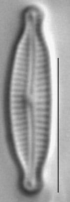
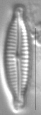
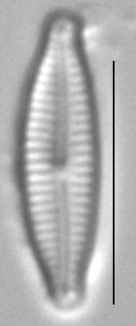
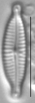
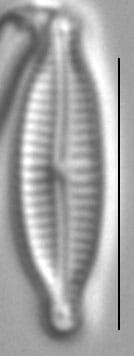
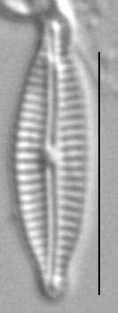
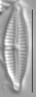
Valves are lanceolate and weakly dorsiventral with slightly convex dorsal and ventral sides. "Shoulders" are lacking. Apices are rostrate in smaller specimens to capitate in larger specimens and deflected slightly ventrally. The axial area is very narrow, barely wider than the raphe. A central area is lacking. The raphe is filiform. Raphe branches are bowed with the convex side of the bow towards the ventral margin. Proximal raphe ends are not or only slightly expanded. Distal raphe ends are hooked ventrally. Striae are radiate, becoming parallel near the apices. Areolae cannot be resolved in LM.
Encyonopsis minuta is widely distributed in temperate and boreal regions (Krammer 1997). The population shown here was collected in East Spring Creek, a small tributary of the Flathead River in northwestern Montana. Encyonopsis minuta is widespread and locally abundant in lakes and spring creeks in the Northern Rockies. Here pH ranged from 8.04 to 9.10 and specific conductance ranged from 93 to 129 µS/cm. In these relatively pristine habitats, E. minuta is often found in association with E. subminuta, but not with the more pollution tolerant E. microcephala.


Bahls, L. (2013). Encyonopsis minuta. In Diatoms of North America. Retrieved June 29, 2026, from https://diatoms.org/species/49136/encyonopsis_minuta
The 15 response plots show an environmental variable (x axis) against the relative abundance (y axis) of Encyonopsis minuta from all the stream reaches where it was present. Note that the relative abundance scale is the same on each plot. Explanation of each environmental variable and units are as follows:
ELEVATION = stream reach elevation (meters)
STRAHLER = distribution plot of the Strahler Stream Order
SLOPE = stream reach gradient (degrees)
W1_HALL = an index that is a measure of streamside (riparian) human activity that ranges from 0 - 10, with a value of 0 indicating of minimal disturbance to a value of 10 indicating severe disturbance.
PHSTVL = pH measured in a sealed syringe sample (pH units)
log_COND = log concentration of specific conductivity (µS/cm)
log_PTL = log concentration of total phosphorus (µg/L)
log_NO3 = log concentration of nitrate (µeq/L)
log_DOC = log concentration of dissolved organic carbon (mg/L)
log_SIO2 = log concentration of silicon (mg/L)
log_NA = log concentration of sodium (µeq/L)
log_HCO3 = log concentration of the bicarbonate ion (µeq/L)
EMBED = percent of the stream substrate that is embedded by sand and fine sediment
log_TURBIDITY = log of turbidity, a measure of cloudiness of water, in nephelometric turbidity units (NTU).
DISTOT = an index of total human disturbance in the watershed that ranges from 1 - 100, with a value of 0 indicating of minimal disturbance to a value of 100 indicating severe disturbance.