Staurosirella pinnata

-
Category
-
Length Range4-10 µm
-
Width Range3-4 µm
-
Striae in 10 µm11-14
-
Contributor
-
ReviewerSam Rushforth - Aug 2013
Identification


Description
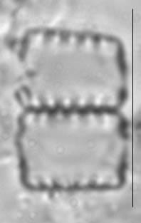
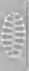
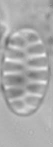
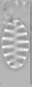
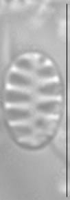
Valves are ovoid, 3-4 µm wide and 4-10 µm long with rounded ends. Valve face flat, or slightly undulate due to raised costae. In girdle view, frustules are rectangular and form ribbon-like colonies, joined by linking spines. Colonies are attached to the substratum at one end by a frustule with a a mucilage pad, or colonies may be planktonic. Axial area is linear to lanceolate. Striae are distinct, 11-14 in 10 µm. Lineolae are long, forming wide striae. Striae vary from parallel in the valve center to radiate toward the valve ends. Striae extend onto the valve mantle. Costae are more slender than the striae. Spines are positioned on costae along the valve margin, except at the apices. Spines are conical at the base and spatulate towards the terminus. A single apical pore field with round poroids is present, displaced toward valve mantle. Girdle bands are open and do not bear perforations.
Samples collected from North America exhibit several morphological variants that are often included under the name Staurosirella pinnata. Since the type of this taxon has not been studied in detail, it is difficult to determine which of these variants corresponds to the “true” S. pinnata. We consider the specimens depicted in this page closely resemble the iconotype specimens presented by Ehrenberg (1843).
Autecology
This taxon is widely distributed in freshwater (Patrick and Reimer 1966), and has been reported with light micrographs from lakes in the Northeastern US (Camburn and Charles 2000), northern Québec and Labrador (Fallu et al. 2000), Cape Cod (Siver et al. 2005), the Canadian Arctic Archipelago (Antoniades et al. (2008), the Great Lakes (Reavie and Kireta 2015),
In the Great Lakes National Parks (Edlund et al. 2009, 2011, 2012, 2013), this taxon is common (5-25% abundance) to uncommon (1-5% abundance) in sediment core material from Isle Royale (Ahmik, Richie and Harvey lakes), Pictured Rocks (Grand Sable and Beaver lakes), Voyageurs ( Ek, Peary, Little Trout, and Mukooda lakes), Sleeping Bear Dunes (Manitou and Bass lakes), and the St. Croix Scenic Riverway (Lake St. Croix).
This taxon is reported to be an indicator of moderate environmental stress (Reavie and Kireta 2015).
Many research groups consider this taxon an indicator organism and published regional environmental optima and tolerances including:
Camburn and Charles (2000): pH - 7.15 +/- 0.55, Acid Neutralizing Capacity - 174 +/- 128 µeq/L, Total Aluminum - 36 +/- 42 µg/L, Dissolved Organic Carbon (DOC) - 129 +/- 174 µmol/L, Total Phosphorus (TP) - 11.15 +/- 6.36 µg/L for populations from the Northeastern US.
Fallu et al. (2000): DOC - 5.46 +/- 1.49 mg/L, Color - 18 +/- 2.9 Pt units, Alkalinity - 69 +/- 2.7 µeq/L for populations from northern Québec and Labrador.
Siver et al. (2005): pH - 6.5 +/- 0.7, TP - 14.3 +/- 7 µg/L for populations from Cape Cod.
Antoniades et al. (2008): pH - 7.5, Tolerance Range - 6.8-8.1, Conductivity - 47 µS/cm, Tolerance Range - 16-132 µS/cm, Dissolved Organic Carbon - 1.27 mg/L, Tolerance Range - 0.76-2.12 µS/cm for populations from the Canadian Arctic Archipelago.
Reavie and Kireta (2015): Report this taxon to have a total phosphorus optima just below 30 µg/L and a chlorine optima just below 10 µg/L for populations in the Great Lakes.
-
Size Range, µm3
-
Motility
-
Attachment
-
Habitat
-
BCG
-
Waterbody
-
Distribution
- Learn more about this
Original Description
F. pinnata, lineari-oblonga striis validis in 1/100 lin. 15, apicibus simpliciter rotundatis. Affinis striolatae et syricae. Icon!
-
BasionymFragilaria pinnata
-
AuthorEhrenb. 1843
Original Images


Citations & Links
Citations
-
Publication Link: 10.1007/s10933-008-9296-1
Links
-
Index Nominum Algarum
-
GenBank
-
North American Diatom Ecological DatabaseNADED ID: 175005
Updates
Feb 11, 2026 - Addition of Autecology
From 2010 to until 2026, the autecological information on this taxon page was limited. As of this update, information on ecology, biogeography, and environmental optima have been added. - Lane Allen and Mark Edlund
Cite This Page
Morales, E., Edlund, M., Allen, L. (2010). Staurosirella pinnata. In Diatoms of North America. Retrieved July 22, 2026, from https://diatoms.org/species/44990/staurosirella_pinnata
Responses
The 15 response plots show an environmental variable (x axis) against the relative abundance (y axis) of Staurosirella pinnata from all the stream reaches where it was present. Note that the relative abundance scale is the same on each plot. Explanation of each environmental variable and units are as follows:
ELEVATION = stream reach elevation (meters)
STRAHLER = distribution plot of the Strahler Stream Order
SLOPE = stream reach gradient (degrees)
W1_HALL = an index that is a measure of streamside (riparian) human activity that ranges from 0 - 10, with a value of 0 indicating of minimal disturbance to a value of 10 indicating severe disturbance.
PHSTVL = pH measured in a sealed syringe sample (pH units)
log_COND = log concentration of specific conductivity (µS/cm)
log_PTL = log concentration of total phosphorus (µg/L)
log_NO3 = log concentration of nitrate (µeq/L)
log_DOC = log concentration of dissolved organic carbon (mg/L)
log_SIO2 = log concentration of silicon (mg/L)
log_NA = log concentration of sodium (µeq/L)
log_HCO3 = log concentration of the bicarbonate ion (µeq/L)
EMBED = percent of the stream substrate that is embedded by sand and fine sediment
log_TURBIDITY = log of turbidity, a measure of cloudiness of water, in nephelometric turbidity units (NTU).
DISTOT = an index of total human disturbance in the watershed that ranges from 1 - 100, with a value of 0 indicating of minimal disturbance to a value of 100 indicating severe disturbance.
Staurosirella pinnata
- Valves oval
- Areolae lineolate
- Costae with spines
Striae are composed of pronounced lineolate areolae; costae are narrow. Solid spines are positioned on the costae. In the SEM, spines are conical at the base, becoming spatulate near the terminus. Porefields are absent.