Neidium hitchcockii

-
Category
-
Length Range44.9-84.7 µm
-
Width Range14.4-22 µm
-
Striae in 10 µm19-21
-
SynonymsSchizonema hitchcockii (Ehrenb.) Kuntze
Vanheurckia rhomboides var. hitchcockii (Ehrenb.) Playfair
-
ContributorEllie Broadman, Meredith Tyree Polaskey - May 2018
-
ReviewerMark Edlund - Sep 2018
Identification


Description
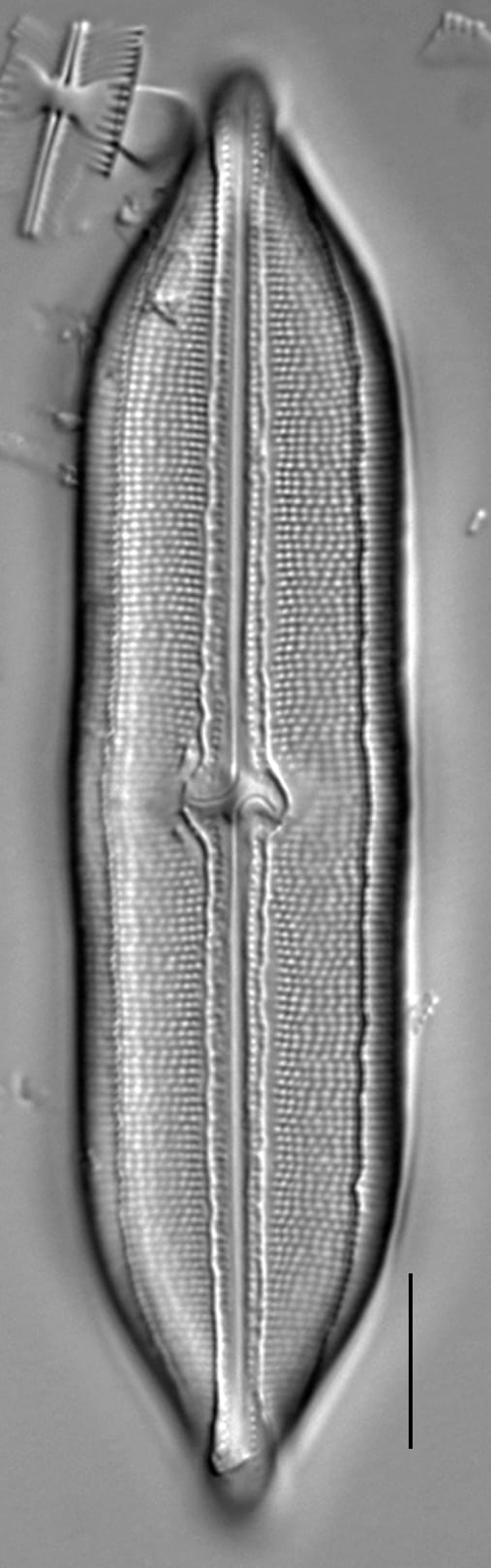
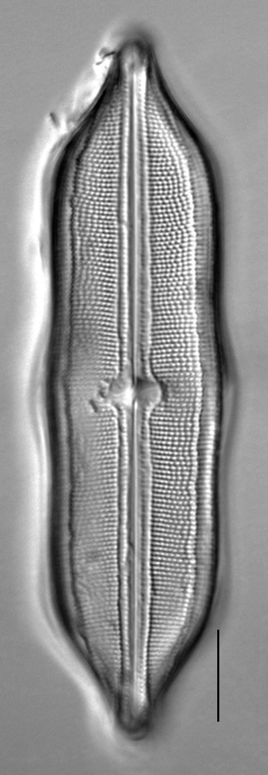
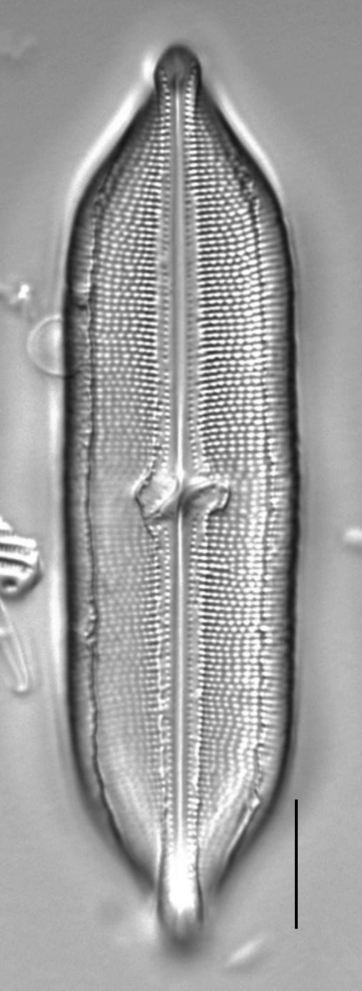
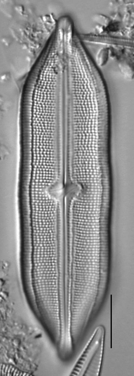
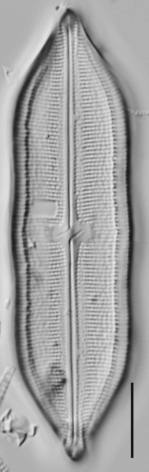
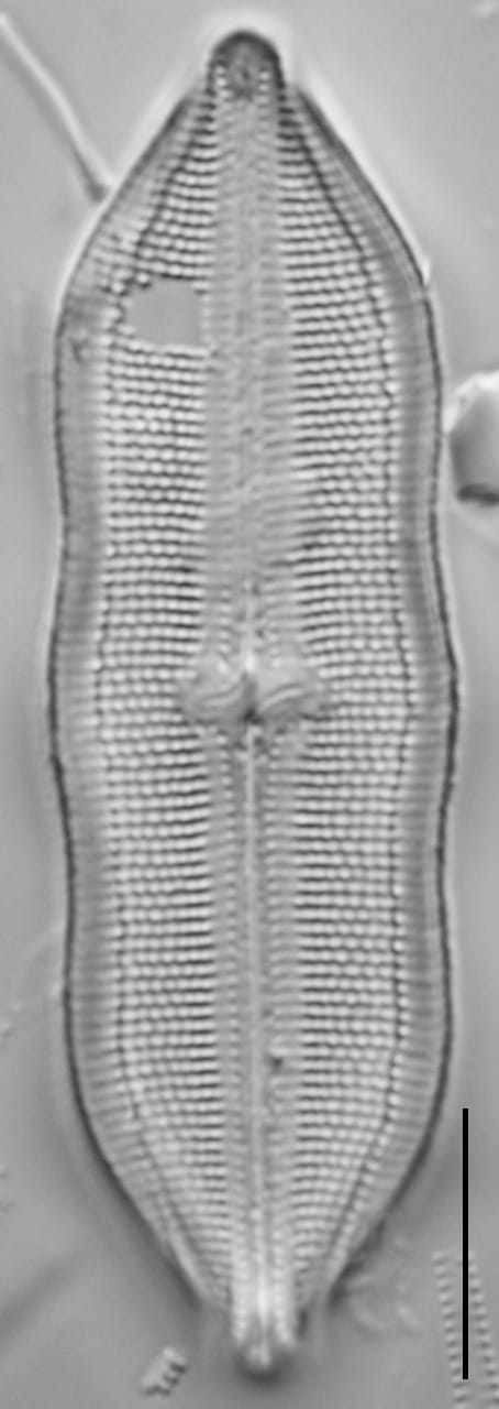
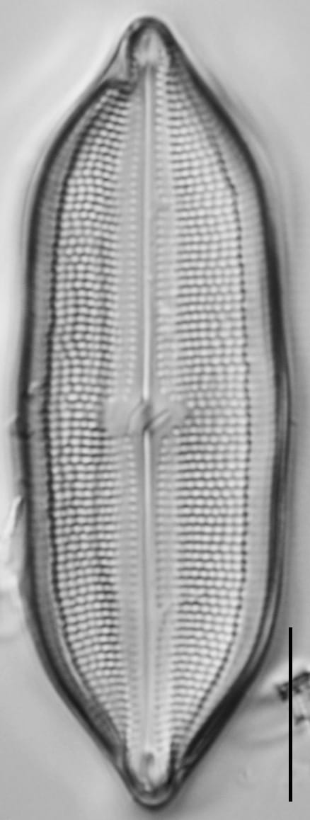
Valves are linear-lanceolate with triundulate margins. Undulations are more distinct on larger specimens, and still visible, but less pronounced on smaller specimens. The undulations are roughly equal in width, and encompass the majority of the valve margin. The valve ends taper to cuneate, apiculate apices. Relatively broad longitudinal canals are present along the valve margins. The raphe and axial area are linear and are bordered by a distinctive conopeum-like structure. Proximal raphe fissures are long, extending to, or at, the edge of the central area. The fissures are prominently deflected in opposite directions. The angle of deflection is variable, from 45° to 90°to recurved. Distal raphe ends are filiform. The central area is small and transversely oblong. Striae are punctate, parallel to slightly radiate, and become slightly convergent at the apices. Voigt faults are often, though not always, present.
Autecology
Neidium hitchcockii occurs in slightly acidic to circumneutral lentic environments throughout the U.S., particularly the northeast (Camburn and Charles 2000, Siver et al., 2005).
The specimens of N. hitchcockii illustrated here were found in lake sediments in multiple regions of North America. Some were found in sediments from lakes in the Kenai Peninsula lowlands in south-central Alaska, namely from a surface sediment sample from Rainbow Lake and from a sediment core from Sunken Island Lake. Other specimens were found in sediments from lakes in Connecticut, Maine, and New Hampshire.
The distribution of Neidium hitchcockii has been verifed from several locations: mainland Alaska (Foged, 1981) and Adak Island (Hein, 1990), Cape Cod (Siver et al., 2005), Iceland (Foged, 1974), and Great Britain (Hartley, 1996).
-
Size Range, µm3
-
Motility
-
Attachment
-
Habitat
-
Colony
-
Occurrence
-
Waterbody
-
Distribution
- Learn more about this
Original Description
146 N. Hitchcockii, testula a dorso late linearis oblonga, lateribus bis constri-ctis aequaliter ter undatis, apicibus subito cuneatis subacutis.
NOTE: Original description of Navicula hitchcockii (Ehrenberg 1843, p. 418). The type locality of Navicula hitchcockii is Bridgewater, Massachusetts (Ehrenberg 1843, p. 382).
-
BasionymNavicula hitchcockii
-
AuthorEhrenb. 1843
Original Images


Citations & Links
Citations
Links
-
Index Nominum Algarum
-
DiatomBase
-
GenBank
-
North American Diatom Ecological DatabaseNADED ID: 47028
Cite This Page
Broadman, E., Polaskey, M. (2018). Neidium hitchcockii. In Diatoms of North America. Retrieved April 02, 2026, from https://diatoms.org/species/62367/neidium-hitchcockii
Responses
The 15 response plots show an environmental variable (x axis) against the relative abundance (y axis) of Neidium hitchcockii from all the stream reaches where it was present. Note that the relative abundance scale is the same on each plot. Explanation of each environmental variable and units are as follows:
ELEVATION = stream reach elevation (meters)
STRAHLER = distribution plot of the Strahler Stream Order
SLOPE = stream reach gradient (degrees)
W1_HALL = an index that is a measure of streamside (riparian) human activity that ranges from 0 - 10, with a value of 0 indicating of minimal disturbance to a value of 10 indicating severe disturbance.
PHSTVL = pH measured in a sealed syringe sample (pH units)
log_COND = log concentration of specific conductivity (µS/cm)
log_PTL = log concentration of total phosphorus (µg/L)
log_NO3 = log concentration of nitrate (µeq/L)
log_DOC = log concentration of dissolved organic carbon (mg/L)
log_SIO2 = log concentration of silicon (mg/L)
log_NA = log concentration of sodium (µeq/L)
log_HCO3 = log concentration of the bicarbonate ion (µeq/L)
EMBED = percent of the stream substrate that is embedded by sand and fine sediment
log_TURBIDITY = log of turbidity, a measure of cloudiness of water, in nephelometric turbidity units (NTU).
DISTOT = an index of total human disturbance in the watershed that ranges from 1 - 100, with a value of 0 indicating of minimal disturbance to a value of 100 indicating severe disturbance.
Neidium hitchcockii
- Valve margins triundulate
- Conopeum-like structure
- Proximal raphe fissures are long and variable in deflection
- Longitudinal canals present at valve margins
Valves are linear-lanceolate and triundulate with apicuate apices. A distinctive conopeum-like structure borders the raphe. Longitudinal canals border the valve margins. Proximal raphe ends are long and deflect in opposite direction. The angle of deflection is variable, from 45° to 90°to recurved.